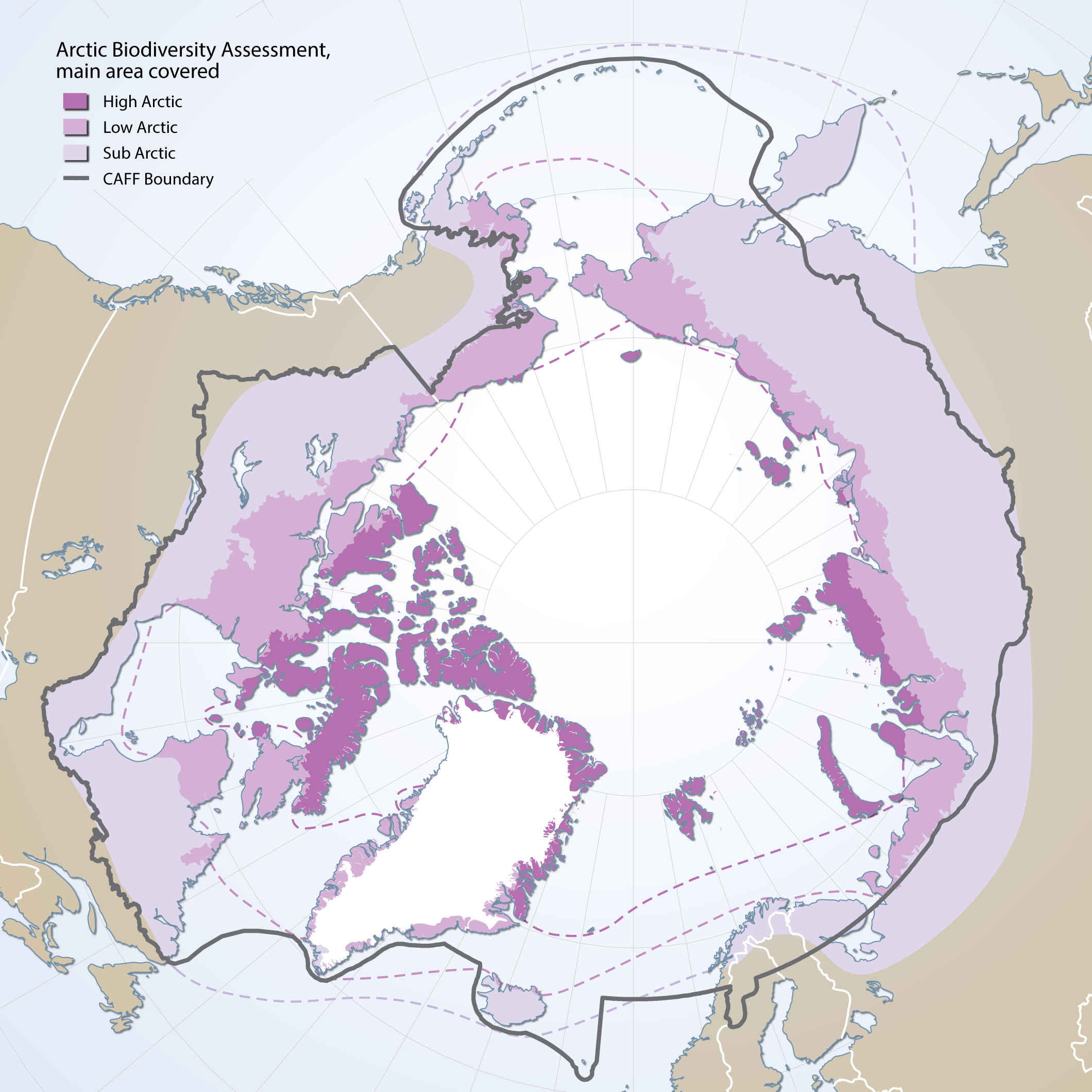
Boundaries of the geographic area covered by the Arctic Biodiversity Assessment
Boundaries of the geographic area covered by the Arctic Biodiversity Assessment. Includes sub, low and high Arctic bounbaries
Simple
- Date (Creation)
- 2001-02-01
- Date (Revision)
- Date (Publication)
- Citation identifier
- https://geo.abds.is/geonetwork/f0eb86a7-e408-4138-9432-dedb991f13d1
- Citation identifier
- http://geo.abds.is:8081/geonetworkf0eb86a7-e408-4138-9432-dedb991f13d1
- Cited responsible party
-
Organisation name Individual name Electronic mail address Role CAFF
Conservation of Arctic Flora and Fauna (CAFF)
Owner
- Presentation form
- Digital map
- Credit
-
High and low Arctic terrestrial boundaries were defined by the Circumpolar Arctic Vegetation Mapping Project - Bioclimatic subzones (CAVM). http://www.geobotany.uaf.edu/cavm/. Sub Arctic boundary was defined by the Arctic Biodiversity Assessment (ABA)
- Point of contact
-
Organisation name Individual name Electronic mail address Role CAFF
Conservation of Arctic Flora and Fauna (CAFF)
Owner
- Maintenance and update frequency
- As needed
- Metadata author
-
Organisation name Individual name Electronic mail address Role CAFF
Conservation of Arctic Flora and Fauna (CAFF)
Owner
- Theme
-
-
boundary
-
Sub Arctic
-
Low Arctic
-
High Arctic
-
ABA
-
Arctic Biodiversity Assessment
-
CAFF
-
-
GEMET - INSPIRE themes, version 1.0
-
-
Area management/restriction/regulation zones and reporting units
-
Bio-geographical regions
-
- Spatial representation type
- Vector
- Language
- English
- Character set
- UTF8
- Environment description
-
Version 6.2 (Build 9200) ; Esri ArcGIS 10.1.1.3143
))
- Reference system identifier
- EPSG / 3408 / 7.11.2
- Distribution format
-
Name Version Shapefile
Digital transfer options
- OnLine resource
-
Protocol Linkage Name OGC:WMS
https://geo.abds.is/geoserver/base/wms? arctic_zones_complete_polygons_4326
WWW:DOWNLOAD-1.0-http--download
https://geo.abds.is/geonetwork/srv/api/records/f0eb86a7-e408-4138-9432-dedb991f13d1/attachments/ABA-Boundaries.zip ABA-Boundaries.zip WWW:DOWNLOAD-1.0-http--download
https://geo.abds.is/geonetwork/srv/api/records/f0eb86a7-e408-4138-9432-dedb991f13d1/attachments/ArcticZone_With-CAFF-boundary.png ArcticZone_With-CAFF-boundary.png OGC:WMS-1.3.0-http-get-map
https://geo.abds.is/geoserver/safbr/wms? arcticzone_4326
Digital transfer options
- OnLine resource
-
Protocol Linkage Name WWW:DOWNLOAD-1.0-http--download
https://geo.abds.is/geonetwork/srv/api/records/f0eb86a7-e408-4138-9432-dedb991f13d1/attachments/ABA_Boundaries.jpg ABA_Boundaries.jpg
Conformance result
- Date (Publication)
Metadata
- File identifier
- f0eb86a7-e408-4138-9432-dedb991f13d1 XML
- Metadata language
- English
- Character set
- UTF8
- Hierarchy level
- Dataset
- Date stamp
- 2026-02-19T17:50:58.281777043Z
- Metadata standard name
-
NAP - Metadata
- Metadata standard version
-
1.2
- Metadata author
-
Organisation name Individual name Electronic mail address Role CAFF
Conservation of Arctic Flora and Fauna (CAFF)
Owner
Overviews
Spatial extent
)))
Provided by