 CAFF - Arctic Biodiversity Data Service (ABDS)
SAMBR - Map of marine fish data sources
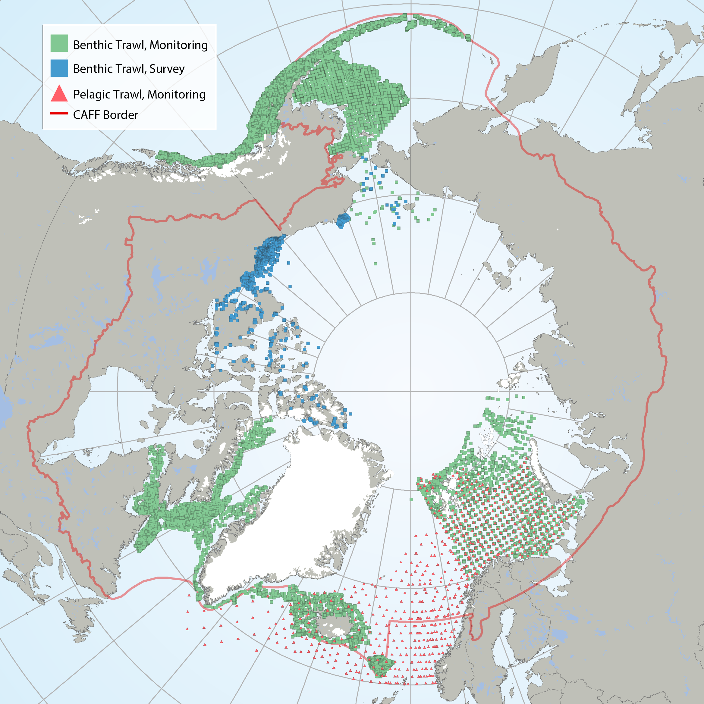
Map of contemporary marine fish data sources. Green squares indicate data from benthic trawl monitoring efforts, blue squares indicate data from benthic trawl surveys, while red triangles indicate data from pelagic trawl monitoring efforts. Red line indicates the CAFF boundary.
STATE OF THE ARCTIC MARINE BIODIVERSITY REPORT - <a href=" https://arcticbiodiversity.is/findings/marine-fishes" target="_blank">Chapter 3</a> - Page 112 - Figure 3.4.1
Simple
- Date (Publication)
- 2017-05
- Credit
-
Canada: Kevin J. Hedges (lead)
Canada: Shannon MacPhee
Iceland: Hreiðar Þór Valtýsson
Inuit Circumpolar Council: Carolina Behe
Norway: Edda Johannesen
United States: Catherine Mecklenburg
- Status
- Completed
- Point of contact
-
Organisation name Individual name Electronic mail address Role DFO
Kevin Hedges
Author Conservation of Arctic Flora and Fauna (CAFF)
Tom Barry
Point of contact
- Maintenance and update frequency
- Unknown
- Theme
-
-
CHAPTER3
-
Marine fish
-
survey
-
Marine
-
- Place
-
-
Fishes
-
- Access constraints
- Copyright
- Use constraints
- otherRestictions
- Spatial representation type
- Vector
- Language
- English
- Character set
- UTF8
- Topic category
-
- Oceans
- Begin date
- 2000-01-01
- End date
- 2015-12-31
))
- Supplemental Information
-
You can customize the template to suit your needs. You can add
and remove fields and fill out default information (e.g. contact details).
Fields you can not change in the default view may be accessible in the more
comprehensive (and more complex) advanced view. You can even use the XML editor
to create custom structures, but they have to be validated by the system, so
know what you do :-)
- Reference system identifier
- WGS 1984
Digital transfer options
- OnLine resource
-
Protocol Linkage Name WWW:DOWNLOAD-1.0-http--download
https://geo.abds.is/geonetwork/srv/api/records/43fc7e91-b5b7-45b2-ad9f-e025f01cae1a/attachments/CBMP_Arctic_Marine_Fish_Programs-v4.xlsx CBMP_Arctic_Marine_Fish_Programs-v4.xlsx WWW:DOWNLOAD-1.0-http--download
https://geo.abds.is/geonetwork/srv/api/records/43fc7e91-b5b7-45b2-ad9f-e025f01cae1a/attachments/Fig_3_4_1.png Fig_3_4_1.png OGC:WMS-1.3.0-http-get-map
https://geo.abds.is/geoserver/sambr/wms? C3_04f1_cbmp_arctic_marine_fish_programs-v4
- Hierarchy level
- Dataset
Conformance result
- Date (Publication)
Metadata
- File identifier
- 43fc7e91-b5b7-45b2-ad9f-e025f01cae1a XML
- Metadata language
- English
- Character set
- UTF8
- Date stamp
- 2026-02-19T17:49:01.805930127Z
- Metadata standard name
-
ISO 19115:2003/19139
- Metadata standard version
-
1.0
- Metadata author
-
Organisation name Individual name Electronic mail address Role Conservation of Arctic Flora and Fauna (CAFF)
Hólmgrímur Helgason
Publisher
)))