protected areas
Type of resources
Available actions
Keywords
Contact for the resource
Provided by
Years
Representation types
Update frequencies
status
Scale
-
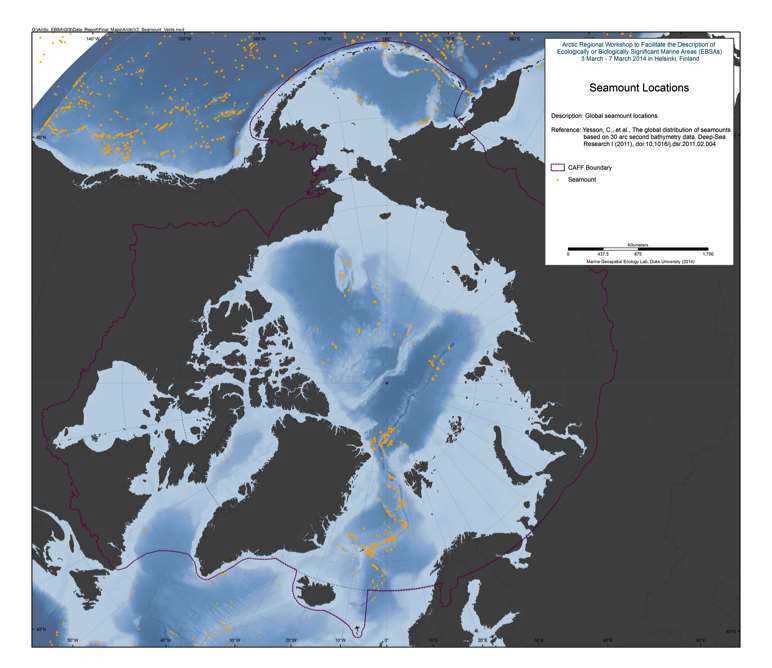
Seamounts and knolls are ‘undersea mountains’, the former rising more than 1000 m from the seafloor. These features provide important habitats for aquatic predators, demersal deep-sea fish and benthic invertebrates. However most seamounts have not been surveyed and their numbers and locations are not well known. Previous efforts to locate and quantify seamounts have used relatively coarse bathymetry grids. Here we use global bathymetric data at 30 arc-second resolution to identify seamounts and knolls. We identify 33,452 seamounts and 138,412 knolls, representing the largest global set of identified seamounts and knolls to date. We compare estimated seamount numbers, locations, and depths with validation sets of seamount data from New Zealand and Azores. This comparison indicates the method we apply finds 94% of seamounts, but may overestimate seamount numbers along ridges and in areas where faulting and seafloor spreading creates highly complex topography. The seamounts and knolls identified herein are significantly geographically biased towards areas surveyed with shipbased soundings. As only 6.5% of the ocean floor has been surveyed with soundings it is likely that new seamounts will be uncovered as surveying improves. Seamount habitats constitute approximately 4.7% of the ocean floor, whilst knolls cover 16.3%. Regional distribution of these features is examined, and we find a disproportionate number of productive knolls, with a summit depth of o1.5 km, located in the Southern Ocean. Less than 2% of seamounts are within marine protected areas and the majority of these are located within exclusive economic zones with few on the High Seas. The database of seamounts and knolls resulting from this study will be a useful resource for researchers and conservation planners. Reference: Yesson, C., et al., The global distribution of seamounts based on 30 arc seconds bathymetry data. Deep-Sea Research I (2011
-
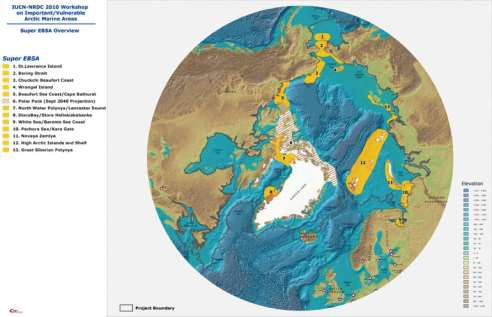
The International Union for the Conservation of Nature (IUCN) and the Natural Resources Defense Council (NRDC) have undertaken a project to explore ways of advancing implementation of ecosystem- based management in the Arctic marine environment through invited expert workshops. The first workshop, held in Washington, D.C. on 16-18 June, 2010, explored possible means to advance policy decisions on ecosystem-based marine management in the Arctic region. Twentynine legal and policy experts from around the region participated in the June workshop. The report and recommendations of the June policy workshop can be found here: <a href="http://cmsdata.iucn.org/downloads/arctic_workshop_report_final.pdf" target="_blank">Workshop report</a> The second workshop, the subject of this report, was held at the Scripps Institution of Oceanography in La Jolla, California on 2-4 November, 2010. The La Jolla workshop utilized criteria developed under auspices of the Convention on Biological Diversity to identify ecologically significant and vulnerable marine areas that should be considered for enhanced protection in any new ecosystem-based management arrangements. A list of participants, the meeting agenda and other relevant documents are attached as appendices to this repor, see: <a href="https://www.nrdc.org/sites/default/files/oce_11042501a.pdf" target="_blank">Workshop report</a>
-
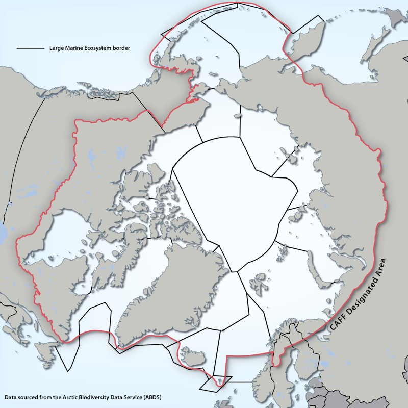
Large Marine Ecosystems (LMEs) are regions of ocean space encompassing coastal areas from river basins and estuaries to the seaward boundary of continental shelves and the seaward margins of coastal current systems. Fifty of them have been identified. They are relatively large regions (200 000 km2 or more) characterized by distinct bathymetry, hydrography, productivity and trophically dependent populations. The LME approach uses five modules: 1. productivity module considers the oceanic variability and its effect on the production of phyto and zooplankton 2. fish and fishery module concerned with the sustainability of individual species and the maintenance of biodiversity 3. pollution and ecosystem health module examines health indices, eutrophication, biotoxins, pathology and emerging diseases 4. socio-economic module integrates assessments of human forcing and the long-term sustainability and associated socio-economic benefits of various management measures, and 5. governance module involves adaptive management and stakeholder participation.” Source: http://www.fao.org/fishery/topic/3440/en Reference: Sherman, K. and Hempel, G. (Editors) 2009. The UNEP Large Marine Ecosystem Report: A perspective on changing conditions in LMEs of the world’s Regional Seas. UNEP Regional Seas Report and Studies No. 182. United Nations Environment Programme. Nairobi, Kenya. Data available from: http://lme.edc.uri.edu/ - LMEs of the world Updated shape file - 2014
-

Human activity is expanding in the Arctic marine environment, in part due to warming ocean temperatures and the dramatic loss of summer sea ice. New and expanding human uses include fishing, shipping and offshore oil and gas development. All have the potential to place major additional stress on ocean ecosystems which are already undergoing profound change related to warming, sea ice loss, and alterations in ocean chemistry. Because activities conducted in one nation's waters can affect other parts of the region, effective management of some human uses in the Arctic marine environment will require international cooperation. The United Nations Convention on the Law of the Sea, in conjunction with other international agreements and national laws and regulations, provides a general legal foundation. However, new rules may be necessary to protect the Arctic marine environment. Examples of possible areas of international cooperation include: development of new standards for Arctic marine shipping, regulation of new or expanding Arctic fisheries, rules to protect the environment in the course of natural resource development, stricter regulation of Arctic tourism, mechanisms to assess and manage the cumulative impacts of multiple activities affecting the same ecosystems, and procedures for the establishment of representative networks of protected marine areas. Ecosystem-based management has the potential to provide an organizing framework for these new or enhanced management measures in the Arctic. Such an approach, as generally accepted at the international level, includes defining portions of ocean space for management purposes based on oceanographic and ecological criteria, and the development of management arrangements that address all human uses of that space in an integrated fashion. A central element of ecosystem-based management is the identification of ecologically significant or vulnerable areas that should be considered for protection due to their role in maintaining valued ecosystem functions and resilience. This data was created with the purpose to identify these areas within the Arctic marine environment.
-
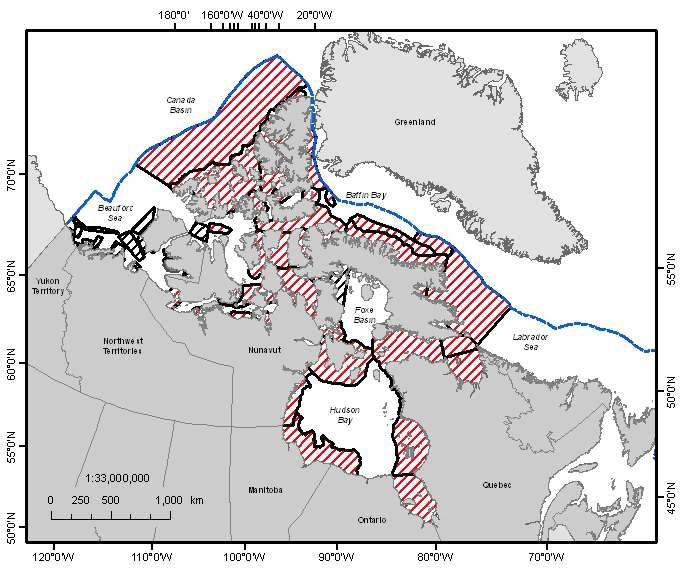
A national Canadian Science Advisory Secretariat (CSAS) science advisory process was held in Winnipeg, Manitoba from June 14-17, 2011 to provide science advice on the identification of Ecologically and Biologically Significant Areas (EBSAs) in the Canadian Arctic based on guidance developed by Fisheries and Oceans Canada. This science advisory process focused on the identification of EBSAs within the following marine biogeographic units: the Hudson Bay Complex, the Arctic Basin, the Western Arctic, the Canadian Arctic Archipelago and the Eastern Arctic. Source: <a href="http://www.dfo-mpo.gc.ca/Library/344747.pdf" target="_blank">Fisheries and Oceans Canada</a> Reference: DFO. 2011. Identification of Ecologically and Biologically Significant Areas (EBSA) in the Canadian Arctic. DFO Can. Sci. Advis. Sec. Sci. Advis. Rep. 2011/055. DFO. 2011. Identification of Ecologically and Biologically Significant Areas (EBSAs) in the Canadian Arctic; June 14-17, 2011. DFO Can. Sci. Advis. Sec. Proceed. Ser. 2011/047.
-
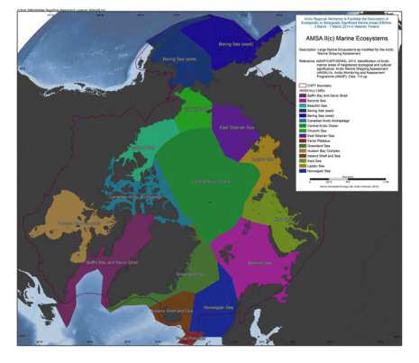
The Arctic Council’s 2009 Arctic Marine Shipping Assessment (AMSA) identified a number of recommendations to guide future action by the Arctic Council, Arctic States and others on current and future Arctic marine activity. Recommendation II C under the theme Protecting Arctic People and the Environment recommended: “That the Arctic states should identify areas of heightened ecological and cultural significance in light of changing climate conditions and increasing multiple marine use and, where appropriate, should encourage implementation of measures to protect these areas from the impacts of Arctic marine shipping, in coordination with all stakeholders and consistent with international law.” As a follow-up to the AMSA, the Arctic Council’s Arctic Monitoring and Assessment Programme (AMAP) and Conservation of Arctic Flora and Fauna (CAFF) working groups undertook to identify areas of heightened ecological significance, and the Sustainable Development Working Group (SDWG) undertook to identify areas of heightened cultural significance. The work to identify areas of heightened ecological significance builds on work conducted during the preparation of the AMAP (2007) Arctic Oil and Gas Assessment. Although it was initially intended that the identification of areas of heightened ecological and cultural significance would be addressed in a similar fashion, this proved difficult. The information available on areas of heightened cultural significance was inconsistent across the Arctic and contained gaps in data quality and coverage which could not be addressed within the framework of this assessment. The areas of heightened cultural significance are therefore addressed within a separate section of the report (Part B) and are not integrated with the information on areas of heightened ecological significance (Part A). In addition, Part B should be seen as instructive in that it illustrates where additional data collection and integration efforts are required, and therefore helps inform future efforts on identification of areas of heightened cultural significance. The results of this work provide the scientific basis for consideration of protective measures by Arctic states in accordance with AMSA recommendation IIc, including the need for specially designated Arctic marine areas as follow-up to AMSA recommendation IId. Reference: AMAP/CAFF/SDWG, 2013. Identification of Arctic marine areas of heightened ecological and cultural significance: Arctic Marine Shipping Assessment (AMSA) IIc. Arctic Monitoring and Assessment Programme (AMAP), Oslo. 114 pp. Data avaiable from: source: <a href="http://www.amap.no/documents/doc/Identification-of-Arctic-marine-areas-of-heightened-ecological-and-cultural-significance-Arctic-Marine-Shipping-Assessment-AMSA-IIc/869" target="_blank">Identification of Arctic marine areas of heightened ecological and cultural significance</a>
 CAFF - Arctic Biodiversity Data Service (ABDS)