Seafloor Geomorphology - Rise
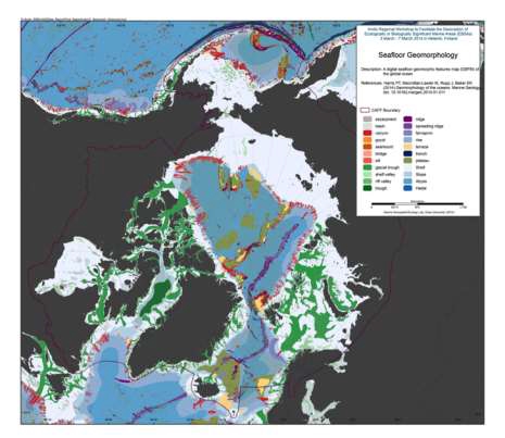
We present the first digital seafloor geomorphic features map (GSFM) of the global ocean. The GSFM includes 131,192 separate polygons in 29 geomorphic feature categories, used here to assess differences between passive and active continental margins as well as between 8 major ocean regions (the Arctic, Indian, North Atlantic, North Pacific, South Atlantic, South Pacific and the Southern Oceans and the Mediterranean and Black Seas). The GSFM provides quantitative assessments of differences between passive and active margins: continental shelf width of passive margins (88 km) is nearly three times that of active margins (31 km); the average width of active slopes (36 km) is less than the average width of passive margin slopes (46 km); active margin slopes contain an area of 3.4 million km2 where the gradient exceeds 5°, compared with 1.3 million km2 on passive margin slopes; the continental rise covers 27 million km2 adjacent to passive margins and less than 2.3 million km2 adjacent to active margins.
Examples of specific applications of the GSFM are presented to show that: 1) larger rift valley segments are generally associated with slow-spreading rates and smaller rift valley segments are associated with fast spreading; 2) polar submarine canyons are twice the average size of non-polar canyons and abyssal polar regions exhibit lower seafloor roughness than non-polar regions, expressed as spatially extensive fan, rise and abyssal plain sediment deposits – all of which are attributed here to the effects of continental glaciations; and 3) recognition of seamounts as a separate category of feature from ridges results in a lower estimate of seamount number compared with estimates of previous workers.
Reference:
Harris PT, Macmillan-Lawler M, Rupp J, Baker EK Geomorphology of the oceans. Marine Geology.
Simple
- Date (Revision)
- 2016-01-28
- Status
- Completed
- Point of contact
-
Organisation name Individual name Electronic mail address Role GRID Arendal
Owner
- Maintenance and update frequency
- As needed
- Theme
-
-
marine
-
abiotic
-
boundary
-
- Place
-
-
seafloor
-
- Access constraints
- Copyright
- Use constraints
- otherRestictions
- Spatial representation type
- Vector
- Language
- English
- Character set
- UTF8
))
- Supplemental Information
-
You can customize the template to suit your needs. You can add
and remove fields and fill out default information (e.g. contact details).
Fields you can not change in the default view may be accessible in the more
comprehensive (and more complex) advanced view. You can even use the XML editor
to create custom structures, but they have to be validated by the system, so
know what you do :-)
- Reference system identifier
- WGS 1984
Digital transfer options
- OnLine resource
-
Protocol Linkage Name WWW:DOWNLOAD-1.0-http--download
https://geo.abds.is/geonetwork/srv/api/records/01ab4a5b-cec0-45e4-a6e9-40c479df24fd/attachments/Figure%201.23-1%20Seafloor%20Geomorphology.tif Figure%201.23-1%20Seafloor%20Geomorphology.tif
WWW:DOWNLOAD-1.0-http--download
https://geo.abds.is/geonetwork/srv/api/records/01ab4a5b-cec0-45e4-a6e9-40c479df24fd/attachments/Rises.zip Rises.zip
OGC:WMS-1.3.0-http-get-map
https://geo.abds.is/geoserver/ebsa/wms? rises
- Hierarchy level
- Dataset
Conformance result
- Date (Publication)
- Pass
Metadata
- File identifier
- 01ab4a5b-cec0-45e4-a6e9-40c479df24fd XML
- Metadata language
- English
- Character set
- UTF8
- Date stamp
- 2026-02-19T17:50:53.838014686Z
- Metadata standard name
-
ISO 19115:2003/19139
- Metadata standard version
-
1.0
- Metadata author
-
Organisation name Individual name Electronic mail address Role CAFF
Point of contact
Overviews
Spatial extent
)))
Provided by