 CAFF - Arctic Biodiversity Data Service (ABDS)
START - Figure 2.3 - Monthly snow cover
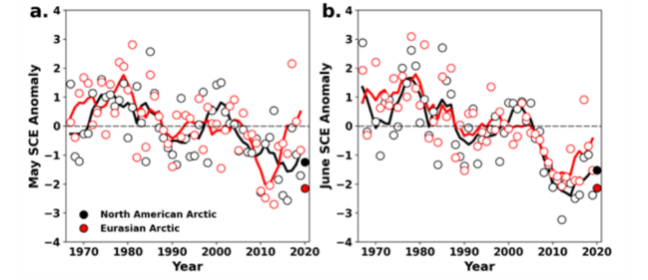
Monthly snow cover extent (SCE) for Arctic land areas (>60° N) for (a) May and (b) June 1967–2020, a 54-year record. Anomalies are relative to the 1981–2010 average and standardised (each observation was differenced from the mean and divided by the standard deviation, and thus unitless). Solid black and red lines depict 5-year running means for North America and Eurasia, respectively. Filled circles are used to highlight 2020 anomalies. (Mudryk et al. 2020).
STATE OF THE ARCTIC TERRESTRIAL BIODIVERSITY REPORT - Chapter 2 - Page 23 - Figure 2.3
Simple
- Date (Publication)
- 2021-05
- Status
- Completed
- Point of contact
-
Organisation name Individual name Electronic mail address Role Conservation of Arctic Flora and Fauna (CAFF)
Tom Barry
Point of contact Conservation of Arctic Flora and Fauna (CAFF)
Kári Fannar Lárusson
Custodian
- Maintenance and update frequency
- Unknown
- Theme
-
-
START
-
CAFF
-
Terrestrial
-
snow
-
temperature
-
- Place
-
-
GEMET - INSPIRE themes, version 1.0
-
-
Land use
-
Land cover
-
- Access constraints
- Copyright
- Use constraints
- otherRestictions
- Spatial representation type
- Vector
- Language
- English
- Character set
- UTF8
- Topic category
-
- Biota
- Climatology, meteorology, atmosphere
- Begin date
- 2021-01-01
))
- Supplemental Information
-
You can customize the template to suit your needs. You can add
and remove fields and fill out default information (e.g. contact details).
Fields you can not change in the default view may be accessible in the more
comprehensive (and more complex) advanced view. You can even use the XML editor
to create custom structures, but they have to be validated by the system, so
know what you do :-)
- Reference system identifier
- WGS 1984
Digital transfer options
- OnLine resource
-
Protocol Linkage Name WWW:LINK-1.0-http--link
OGC:WMS-1.1.1-http-get-map
WWW:LINK-1.0-http--link
https://arcticbiodiversity.is/terrestrial Webpage
WWW:DOWNLOAD-1.0-http--download
https://geo.abds.is/geonetwork/srv/api/records/11668040-93db-4049-96f7-83c0c5c3a08b/attachments/2.3.png 2.3.png
- Hierarchy level
- Dataset
Conformance result
- Date (Publication)
Metadata
- File identifier
- 11668040-93db-4049-96f7-83c0c5c3a08b XML
- Metadata language
- English
- Character set
- UTF8
- Date stamp
- 2026-02-19T17:48:02.63876055Z
- Metadata standard name
-
ISO 19115:2003/19139
- Metadata standard version
-
1.0
- Metadata author
-
Organisation name Individual name Electronic mail address Role Conservation of Arctic Flora and Fauna (CAFF)
Hólmgrímur Helgason
Publisher
)))