 CAFF - Arctic Biodiversity Data Service (ABDS)
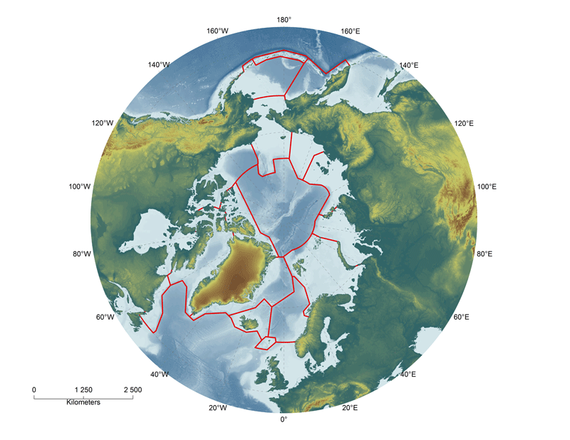
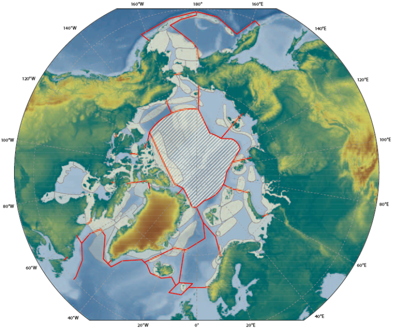
AMSAIIC: Arctic marine areas of heightened ecological significance
A total of 95 areas of heightened ecological significance have been identified within the Arctic LMEs. The areas were identified primarily on the basis of their ecological importance to fish, birds and/or mammals, as these species are the most widely studied Arctic groups. The majority of areas identified are used by birds (85) and marine mammals (81), with a lower number used by fish (40, most of them spawning areas). About 70 areas are used both by birds and mammals, and only two of the areas identified are used only by fish.The areas of heightened ecological significance comprise a total area of about 12 million km2, or more than half the total area of the ice-covered part of the marine Arctic. The areas are generally not homogenous but comprise subareas used by fish, birds or mammals. Based on the approach used, subareas were identified separately for fish, birds, and mammals, or information on the use of the larger areas by these groupswas summarized. The subareas often overlap and are also often used by two or more species of birds or mammals, such as for breeding in seabird colonies or for staging by waterfowl and shorebirds. Information on species present and the times and purposes of use are given in summary tables for each LME. Thus, while the areas identified as being of heightened ecological significance cover a large total area, this is the aggregate area used over all seasons throughout the year. The area used at any one time is lower due to the strong seasonal pattern in the annual migratory cycles of fish, birds and mammals.
Simple
- Date (Creation)
- 2013-05-06
- Date (Publication)
- 2013-05-06
- Edition
-
First edition
- Edition date
- 2013-05-09
- Citation identifier
- https://geo.abds.is/geonetwork/1a87eadd-c170-4ebd-a3cb-81ae1a051b1d
- Citation identifier
- http://geo.abds.is:8081/geonetwork1a87eadd-c170-4ebd-a3cb-81ae1a051b1d
- Cited responsible party
-
Organisation name Individual name Electronic mail address Role Conservation of Arctic Flora and Fauna (CAFF - www.caff.is) Arctic Council biodievrsity Working Group
Tom Barry
Owner
- Presentation form
- Digital map
- Collective title
-
AMAP/CAFF/SDWG, 2013. Identification of Arctic marine areas of heightened ecological and cultural significance: Arctic Marine Shipping Assessment (AMSA) IIc
- Purpose
-
The Arctic Council’s 2009 Arctic Marine Shipping Assessment (AMSA) identified a number of recommendations to guide future action by the Arctic Council, Arctic States and others on current and future Arctic marine activity. Recommendation II C recommended: “That the Arctic states should identify areas of heightened ecological and cultural significance in light of changing climate conditions and increasing multiple marine use and, where appropriate, should encourage implementation of measures to protect these areas from the impacts of Arctic marine shipping, in coordination with all stakeholders and consistent with international law.” As a follow-up to the AMSA, the Arctic Council’s Arctic Monitoring and Assessment Programme (AMAP) and Conservation of Arctic Flora and Fauna (CAFF) working groups undertook to identify areas of heightened ecological significance.
- Credit
-
The Arctic Council’s Arctic Monitoring and Assessment Programme (AMAP) and Conservation of Arctic Flora and Fauna (CAFF) working groups
- Point of contact
-
Organisation name Individual name Electronic mail address Role Conservation of Arctic Flora and Fauna (CAFF)
Tom Barry
Publisher
- Maintenance and update frequency
- Not planned
- Keywords
-
-
Arctic marine
-
AMSAIIC
-
CAFF
-
AMAP
-
SDWG
-
Arctic Council
-
AMSA
-
- Keywords
-
-
Marine sensitive areas
-
-
GEMET - INSPIRE themes, version 1.0
-
-
Sea regions
-
Habitats and biotopes
-
Oceanographic geographical features
-
- Spatial representation type
- Vector
- Language
- English
- Character set
- UTF8
- Topic category
-
- Biota
- Boundaries
- Environment
- Oceans
))
- Reference system identifier
- EPSG / 3408 / 10.1.0
- Topology level
- Geometry only
- Geometric object type
- Composite
- Geometric object count
- 98
- Distribution format
-
Name Version Shapefile
2
Digital transfer options
- OnLine resource
-
Protocol Linkage Name OGC:WMS-1.3.0-http-get-map
https://geo.abds.is/geoserver/amsa2c/wms? AMSAIIC_Significant_Areas
OGC:WMS-1.3.0-http-get-map
https://geo.abds.is/geoserver/abds/wms? lme_2013_wgs
Digital transfer options
- Transfer size
- 3.772
- OnLine resource
-
Protocol Linkage Name WWW:DOWNLOAD-1.0-http--download
https://geo.abds.is/geonetwork/srv/api/records/1a87eadd-c170-4ebd-a3cb-81ae1a051b1d/attachments/AMSAIIC_significance_Areas.zip AMSAIIC_significance_Areas.zip
Digital transfer options
OnLine resource
Digital transfer options
- OnLine resource
-
Protocol Linkage Name WWW:DOWNLOAD-1.0-ftp--download
https://geo.abds.is/geonetwork/srv/api/records/1a87eadd-c170-4ebd-a3cb-81ae1a051b1d/attachments/AMSIIC-Sensitive-Areas.png AMSIIC-Sensitive-Areas.png
Digital transfer options
- OnLine resource
-
Protocol Linkage Name WWW:LINK-1.0-http--link
https://oaarchive.arctic-council.org/items/1d567c4b-723b-48fa-8510-828edede09a7 Online resource
Conformance result
- Date (Publication)
Metadata
- File identifier
- 1a87eadd-c170-4ebd-a3cb-81ae1a051b1d XML
- Metadata language
- English
- Character set
- UTF8
- Hierarchy level
- Dataset
- Hierarchy level name
-
dataset
- Date stamp
- 2026-02-19T17:47:25.67686412Z
- Metadata standard name
-
ISO 19139 Geographic Information - Metadata - Implementation Specification
- Metadata standard version
-
2007
- Metadata author
-
Organisation name Individual name Electronic mail address Role Conservation of Arctic Flora and Fauna (CAFF - www.caff.is) Arctic Council biodievrsity Working Group
Tom Barry
Owner
- Other language
-
Language Character encoding Icelandic UTF8 English UTF8
)))