 CAFF - Arctic Biodiversity Data Service (ABDS)
SAFBR - Figure 4.30 - River BMI diversity
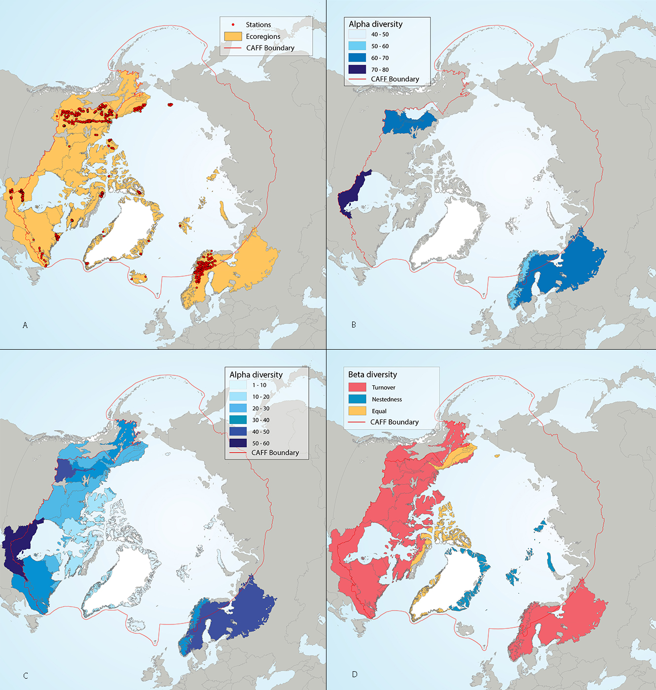
Results of circumpolar assessment of river benthic macroinvertebrates, indicating (a) the location of river benthic macroinvertebrate stations, underlain by circumpolar ecoregions; (b) ecoregions with many river benthic macroinvertebrate stations, colored on the basis of alpha diversity rarefied to 100 stations; (c) all ecoregions with river benthic macroinvertebrate stations, colored on the basis of alpha diversity rarefied to 10 stations; (d) ecoregions with at least two stations in a hydrobasin, colored on the basis of the dominant component of beta diversity (species turnover, nestedness, approximately equal contribution, or no diversity) when averaged across hydrobasins in each ecoregion.
State of the Arctic Freshwater Biodiversity Report - Chapter 4 - Page 67 - Figure 4-30
Simple
- Date (Publication)
- 2019-05
- Status
- Completed
- Point of contact
-
Organisation name Individual name Electronic mail address Role Conservation of Arctic Flora and Fauna (CAFF)
Tom Barry
Point of contact
- Maintenance and update frequency
- Unknown
- Theme
-
-
SAFBR
-
CAFF
-
Freshwater
-
River
-
macroinvertebrate
-
- Place
-
-
benthic
-
- Access constraints
- Copyright
- Use constraints
- otherRestictions
- Spatial representation type
- Vector
- Language
- English
- Character set
- UTF8
- Topic category
-
- Inland waters
))
- Supplemental Information
-
You can customize the template to suit your needs. You can add
and remove fields and fill out default information (e.g. contact details).
Fields you can not change in the default view may be accessible in the more
comprehensive (and more complex) advanced view. You can even use the XML editor
to create custom structures, but they have to be validated by the system, so
know what you do :-)
- Reference system identifier
- WGS 1984
Digital transfer options
- OnLine resource
- Hierarchy level
- Dataset
Conformance result
- Date (Publication)
Metadata
- File identifier
- 4a74fba6-a0be-4318-b327-437d29f786e9 XML
- Metadata language
- English
- Character set
- UTF8
- Date stamp
- 2026-02-19T17:50:11.375933715Z
- Metadata standard name
-
ISO 19115:2003/19139
- Metadata standard version
-
1.0
- Metadata author
-
Organisation name Individual name Electronic mail address Role Conservation of Arctic Flora and Fauna (CAFF)
Hólmgrímur Helgason
Publisher
)))