 CAFF - Arctic Biodiversity Data Service (ABDS)
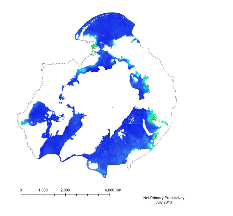
Marine Net Primary Productivity (MYD27)
Marine primary productivity is not available from the NASA Ocean Color website.
Currently the best product available for marine primary productivity is available through Oregon State University’s Ocean Productivity Project. A monthly global Net Primary Productivity product at 9 km spatial resolution has been selected for this analysis. The algorithm used to create the primary productivity is a Vertically Generalized Production Model (VGPM) created by Behrenfeld and Falkowski (1997). It is a “chlorophyll-based” model that estimates net primary production from chlorophyll using a temperature-dependent description of chlorophyll photosynthetic efficiency (O’Malley 2010). Inputs to the function are chlorophyll, available light, and photosynthetic efficiency.
Simple
- Date (Creation)
- 2002-10-01
- Date (Revision)
- Date (Publication)
- Citation identifier
- https://geo.abds.is/geonetwork/566923c0-f10b-4f2f-8c27-2f0098548fdb
- Citation identifier
- http://geo.abds.is:8081/geonetwork566923c0-f10b-4f2f-8c27-2f0098548fdb
- Presentation form
- Digital map
- Credit
-
CAFF
- Point of contact
-
Organisation name Individual name Electronic mail address Role Conservation of Arctic Flora and Fauna (CAFF)
Point of contact
- Place
-
-
marine
-
boundary
-
- Keywords
-
-
model
-
remote sensing
-
invertebrates
-
-
GEMET - INSPIRE themes, version 1.0
-
-
Land cover
-
Orthoimagery
-
- Language
- English
))
- Reference system identifier
- EPSG:3408
- Distribution format
-
Name Version GeoTIFF
1.0
Digital transfer options
- OnLine resource
-
Protocol Linkage Name WWW:LINK-1.0-http--link
http://www.science.oregonstate.edu/ocean.productivity/index.php For more information on this product please see:
Digital transfer options
- OnLine resource
-
Protocol Linkage Name WWW:LINK-1.0-http--link
http://orca.science.oregonstate.edu/2160.by.4320.monthly.hdf.vgpm.m.chl.m.sst4.php Downloaded from Oregon State University:
Digital transfer options
- OnLine resource
-
Protocol Linkage Name WWW:LINK-1.0-http--link
https://abds.is/index.php/indices/land-cover-change-index-edocman Download raw data
Conformance result
- Date (Publication)
- Pass
Metadata
- File identifier
- 566923c0-f10b-4f2f-8c27-2f0098548fdb XML
- Metadata language
- English
- Character set
- UTF8
- Hierarchy level
- Dataset
- Date stamp
- 2026-02-19T17:49:37.917512794Z
- Metadata standard name
-
ISO 19115:2003/19139
- Metadata standard version
-
1.0
- Metadata author
-
Organisation name Individual name Electronic mail address Role Conservation of Arctic Flora and Fauna (CAFF)
Point of contact
)))