 CAFF - Arctic Biodiversity Data Service (ABDS)
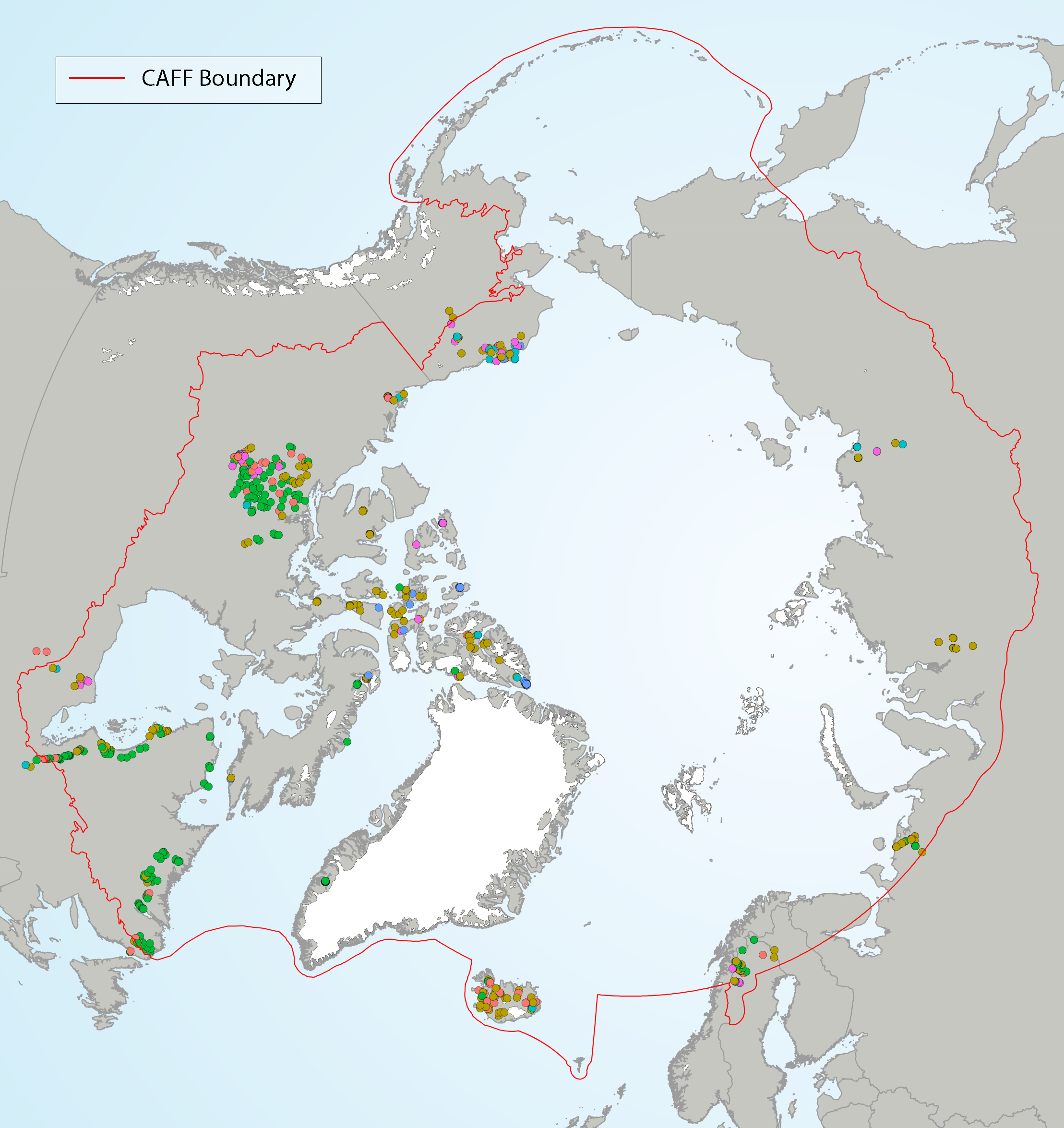
SAFBR - Figure 4.12 - Diatom lake biotypes
Figure 4 12 Diatom groups from Self Organizing Maps (SOMs) in lake top sediments, showing the geographical distribution of each group (with colors representing different SOM groups).
State of the Arctic Freshwater Biodiversity Report - Chapter 4 - Page 39 - Figure 4-12
Simple
- Date (Publication)
- 2019-05
- Status
- Completed
- Point of contact
-
Organisation name Individual name Electronic mail address Role Conservation of Arctic Flora and Fauna (CAFF)
Tom Barry
Point of contact
- Maintenance and update frequency
- Unknown
- Theme
-
-
SAFBR
-
CAFF
-
Freshwater
-
lake
-
- Place
-
-
diatoms
-
- Access constraints
- Copyright
- Use constraints
- otherRestictions
- Spatial representation type
- Vector
- Language
- English
- Character set
- UTF8
- Topic category
-
- Inland waters
))
- Supplemental Information
-
You can customize the template to suit your needs. You can add
and remove fields and fill out default information (e.g. contact details).
Fields you can not change in the default view may be accessible in the more
comprehensive (and more complex) advanced view. You can even use the XML editor
to create custom structures, but they have to be validated by the system, so
know what you do :-)
- Reference system identifier
- WGS 1984
Digital transfer options
- OnLine resource
-
Protocol Linkage Name WWW:LINK-1.0-http--link
OGC:WMS-1.1.1-http-get-map
WWW:DOWNLOAD-1.0-http--download
https://geo.abds.is/geonetwork/srv/api/records/8e9bc0d6-80dc-4b0b-baf3-740885acc2bf/attachments/4-12_shp.zip 4-12_shp.zip OGC:WMS
https://geo.abds.is/geoserver/safbr/wms? fig_4-12
WWW:LINK-1.0-http--link
https://www.caff.is/freshwater/freshwater-monitoring-publications/488-state-of-the-arctic-freshwater-biodiversity-report-full-report State of the Arctic Freshwater Biodiversity Report
WWW:LINK-1.0-http--link
https://caff.is/freshwater Source
- Hierarchy level
- Dataset
Conformance result
- Date (Publication)
Metadata
- File identifier
- 8e9bc0d6-80dc-4b0b-baf3-740885acc2bf XML
- Metadata language
- English
- Character set
- UTF8
- Date stamp
- 2026-02-19T17:46:27.139671253Z
- Metadata standard name
-
ISO 19115:2003/19139
- Metadata standard version
-
1.0
- Metadata author
-
Organisation name Individual name Electronic mail address Role Conservation of Arctic Flora and Fauna (CAFF)
Hólmgrímur Helgason
Publisher
)))