 CAFF - Arctic Biodiversity Data Service (ABDS)
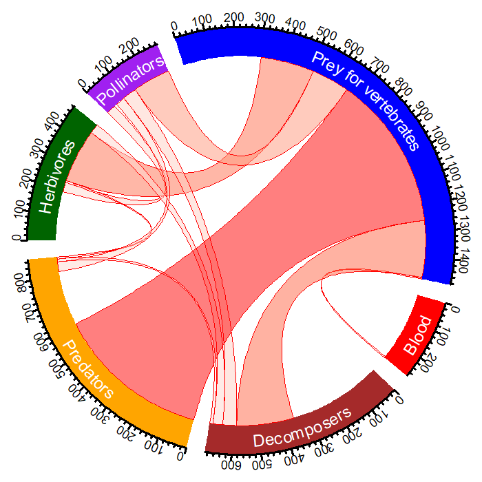
START - Figure 3.8 - Chord diagram illustrating the multi-functionality of Arctic arthropods.
The diagram indicates the number of species in each FEC for the North Atlantic region of the Arctic (circular outline) and the overlap between the five CBMP–Terrestrial Plan FECs and the additional ‘predators’ FEC. The link width indicates the number of species linking two FECs. The larger the link the more species that are found in linking FECs. Modified from Gillespie et al. 2020a.
STATE OF THE ARCTIC TERRESTRIAL BIODIVERSITY REPORT - Chapter 3 - Page 38 - Figure 3.8
Simple
- Date (Publication)
- 2021-05
- Status
- Completed
- Point of contact
-
Organisation name Individual name Electronic mail address Role Conservation of Arctic Flora and Fauna (CAFF)
Tom Barry
Point of contact
- Maintenance and update frequency
- Unknown
- Theme
-
-
START
-
CAFF
-
Terrestrial
-
Arthropods
-
- Place
-
-
GEMET - INSPIRE themes, version 1.0
-
-
Land use
-
Land cover
-
- Access constraints
- Copyright
- Use constraints
- otherRestictions
- Spatial representation type
- Vector
- Language
- English
- Character set
- UTF8
- Topic category
-
- Biota
- Climatology, meteorology, atmosphere
- Begin date
- 2021-01-01
))
- Supplemental Information
-
You can customize the template to suit your needs. You can add
and remove fields and fill out default information (e.g. contact details).
Fields you can not change in the default view may be accessible in the more
comprehensive (and more complex) advanced view. You can even use the XML editor
to create custom structures, but they have to be validated by the system, so
know what you do :-)
- Reference system identifier
- WGS 1984
Digital transfer options
- OnLine resource
-
Protocol Linkage Name WWW:LINK-1.0-http--link
OGC:WMS-1.1.1-http-get-map
WWW:LINK-1.0-http--link
https://arcticbiodiversity.is/terrestrial Webpage
WWW:DOWNLOAD-1.0-http--download
https://geo.abds.is/geonetwork/srv/api/records/90eae4b7-337d-4168-8f36-dc25c3758a8c/attachments/chord.png chord.png
- Hierarchy level
- Dataset
Conformance result
- Date (Publication)
Metadata
- File identifier
- 90eae4b7-337d-4168-8f36-dc25c3758a8c XML
- Metadata language
- English
- Character set
- UTF8
- Date stamp
- 2026-02-19T17:48:47.208901149Z
- Metadata standard name
-
ISO 19115:2003/19139
- Metadata standard version
-
1.0
- Metadata author
-
Organisation name Individual name Electronic mail address Role Conservation of Arctic Flora and Fauna (CAFF)
Hólmgrímur Helgason
Publisher
)))