 CAFF - Arctic Biodiversity Data Service (ABDS)
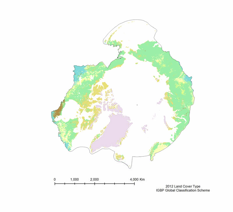
Land Cover Type
The MODIS Land Cover Type product is created yearly using three landclassification schemes; the International Geosphere Biosphere Programme (IGBP)classification scheme, the Univertiy of Maryland (UMD) classification scheme, and aMODIS-derived Leaf Area Index /Fraction of Photosynthetically Active Radiation(LAI/fPAR) classification scheme (Table 3).
The International Geosphere Biosphere Programme (IGBP) identifies seventeenland cover classes, including eleven natural vegetation classes, three non-vegetated landclasses, and three developed land classes. The product provided is derived using the samealgorithm as the 500 m Land Cover Type (MOD12Q1), but is on a 0.05° Climate Model Grid(CMG), that has been clipped to the pan-Arctic extent. The UMD classification scheme issimilar to the IGBP classification scheme, but it excludes the Permanent wetlands,Cropland/Natural vegetation mosaic, and the Snow and ice classes.
The LAI/fPARclassification scheme is the smallest of the three, and focuses on forest structure; it only haseleven classes. All three land cover classification schemes are provided, but the IGBPclassification scheme is the most amenable to the Pan-Arctic region.
Simple
- Alternate title
-
MCD12C1
- Date (Publication)
- 2014-12-16
- Date (Revision)
- Date (Creation)
- Citation identifier
- https://geo.abds.is/geonetwork/97992604-f60e-4446-bbda-d98ec4a992d3
- Citation identifier
- http://geo.abds.is:8081/geonetwork97992604-f60e-4446-bbda-d98ec4a992d3
- Cited responsible party
-
Organisation name Individual name Electronic mail address Role Conservation of Arctic Flora and Fauna (CAFF)
Point of contact
- Credit
-
Conservation of Arctic Flora and Fauna (CAFF www.caff.is) working group of the Arctic Council
- Maintenance and update frequency
- Irregular
- Keywords
-
-
MODIS
-
remote sensing
-
terrestrial
-
boundary
-
- Keywords
-
-
Land Cover Type
-
UMD
-
MOD12Q1
-
-
GEMET - INSPIRE themes, version 1.0
-
-
Orthoimagery
-
Geology
-
Land cover
-
- Language
- English
))
- Reference system identifier
- EPSG / 102017
Digital transfer options
- OnLine resource
-
Protocol Linkage Name OGC:WMS
https://geo.abds.is/geoserver/arctic_sdi/wms? 2019_LandCoverType
Digital transfer options
- OnLine resource
-
Protocol Linkage Name WWW:DOWNLOAD-1.0-http--download
https://geo.abds.is/geonetwork/srv/api/records/97992604-f60e-4446-bbda-d98ec4a992d3/attachments/Land-Cover-Type.jpg Land-Cover-Type.jpg
Digital transfer options
- OnLine resource
-
Protocol Linkage Name WWW:LINK-1.0-http--link
https://abds.is/index.php/indices/land-cover-change-index-edocman
- Hierarchy level
- Dataset
Conformance result
- Date (Publication)
Metadata
- File identifier
- 97992604-f60e-4446-bbda-d98ec4a992d3 XML
- Metadata language
- English
- Character set
- UTF16
- Hierarchy level
- Dataset
- Date stamp
- 2026-02-19T17:51:32.540849538Z
- Metadata standard version
-
1.2
- Metadata author
-
Organisation name Individual name Electronic mail address Role Conservation of Arctic Flora and Fauna (CAFF)
Point of contact
)))