 CAFF - Arctic Biodiversity Data Service (ABDS)
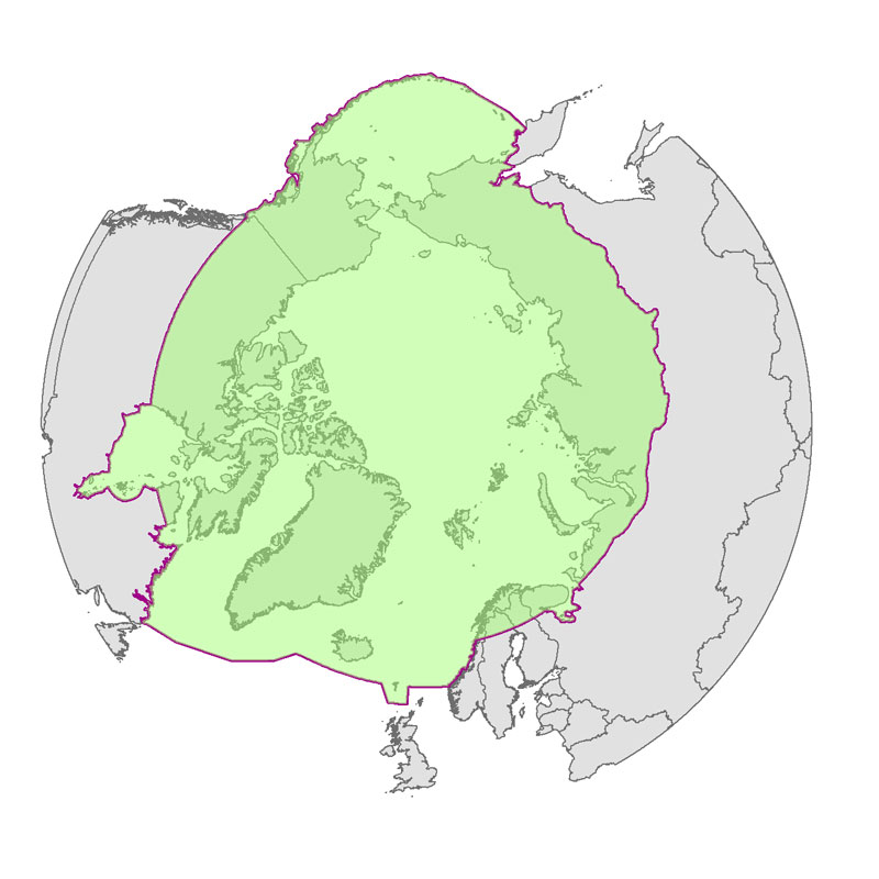
Boundary for Arctic Assessment and Monitoring Programme (AMAP) working group of the Arctic Council
Defines the area covered by the the Arctic Assessment and Monitoring Programme (AMAP www.amap.no) working group of the Arctic Council.
Simple
- Date
- Date (Revision)
- Date (Creation)
- Date (Publication)
- Citation identifier
- https://geo.abds.is/geonetwork/9BB31CE7-9AE2-453D-9234-0BAEB5C8A33C
- Citation identifier
- http://geo.abds.is:8081/geonetwork9BB31CE7-9AE2-453D-9234-0BAEB5C8A33C
- Cited responsible party
-
Organisation name Individual name Electronic mail address Role Arctic Assessment and Monitoring Programme (AMAP www.amap.no) working group of the Arctic Council.
Owner
- Presentation form
- Digital map
- Credit
-
Arctic Assessment and Monitoring Programme (AMAP www.amap.no) working group of the Arctic Council
- Point of contact
-
Organisation name Individual name Electronic mail address Role Arctic Assessment and Monitoring Programme (AMAP www.amap.no) working group of the Arctic Council.
Owner
- Maintenance and update frequency
- As needed
- Metadata author
-
Organisation name Individual name Electronic mail address Role Arctic Assessment and Monitoring Programme (AMAP www.amap.no) working group of the Arctic Council.
Owner
- Theme
-
-
boundary
-
AMAP
-
- Keywords
-
- Spatial representation type
- Vector
- Language
- English
- Character set
- UTF8
- Environment description
-
Version 6.2 (Build 9200) ; Esri ArcGIS 10.1.1.3143
))
- Reference system identifier
- EPSG / 3408 / 7.11.2
- Topology level
- Geometry only
- Geometric object type
- Composite
- Geometric object count
- 1
- Distribution format
-
Name Version Shapefile
Digital transfer options
- Transfer size
- 0.021
- OnLine resource
-
Protocol Linkage Name WWW:DOWNLOAD-1.0-http--download
https://geo.abds.is/geonetwork/srv/api/records/9BB31CE7-9AE2-453D-9234-0BAEB5C8A33C/attachments/amap.jpg amap.jpg OGC:WMS-1.3.0-http-get-capabilities
https://geo.abds.is/geoserver/Boundaries/wms? amaplim_geo_nw
OGC:WMS-1.3.0-http-get-capabilities
https://geo.abds.is/geoserver/Boundaries/wms? amaplim_lam_poly
WWW:LINK-1.0-http--link
http://www.amap.no/documents/doc/amap-area-gis/868 AMAP Page
Digital transfer options
Digital transfer options
Digital transfer options
Digital transfer options
Conformance result
- Date (Publication)
Metadata
- File identifier
- 9BB31CE7-9AE2-453D-9234-0BAEB5C8A33C XML
- Metadata language
- English
- Character set
- UTF8
- Hierarchy level
- Dataset
- Date stamp
- 2026-02-19T17:46:58.328338792Z
- Metadata standard name
-
NAP - Metadata
- Metadata standard version
-
1.2
- Metadata author
-
Organisation name Individual name Electronic mail address Role Arctic Assessment and Monitoring Programme (AMAP www.amap.no) working group of the Arctic Council.
Point of contact
)))