 CAFF - Arctic Biodiversity Data Service (ABDS)
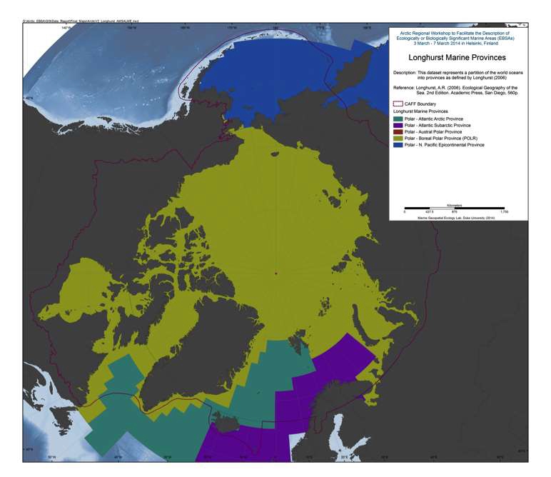
Longhurst Marine Provinces
This dataset represents a partition of the world oceans into provinces as defined by Longhurst (1995; 1998; 2006), and are based on the prevailing role of physical forcing as a regulator of phytoplankton distribution. The dataset represents the initial static boundaries developed at the Bedford Institute of Oceanography, Canada. Note that the boundaries of these provinces are not fixed in time and space, but are dynamic and move under seasonal and interannual changes in physical forcing. At the first level of reduction, Longhurst recognized four principal biomes (also referred to as domains in earlier publications): the Polar Biome, the Westerlies Biome, the Trade-Winds Biome, and the Coastal Boundary Zone Biome. These four Biomes are recognizable in every major ocean basin. At the next level of reduction, the ocean basins are partitioned into provinces, roughly ten for each basin. These partitions provide a template for data analysis or for making parameter assignments on a global scale.
(source: VLIZ (2009). Longhurst Biogeographical Provinces. Available online at <a href=" http://www.marineregions.org/" target="_blank">Longhurst Biogeographical Provinces</a>
References:
Longhurst, A.R. (2006). Ecological Geography of the Sea. 2nd Edition. Academic Press, San Diego, 560p. Data available from: <a href=" http://www.marineregions.org/sources.php#longhurst" target="_blank">Ecological Geography of the Sea</a>
Simple
- Date (Revision)
- 2016-01-25
- Status
- Completed
- Point of contact
-
Organisation name Individual name Electronic mail address Role MarineRegions.org
Owner
- Maintenance and update frequency
- As needed
- Theme
-
-
boundary
-
marine
-
- Place
-
- Access constraints
- Copyright
- Use constraints
- otherRestictions
- Spatial representation type
- Vector
- Language
- English
- Character set
- UTF8
))
- Supplemental Information
-
You can customize the template to suit your needs. You can add
and remove fields and fill out default information (e.g. contact details).
Fields you can not change in the default view may be accessible in the more
comprehensive (and more complex) advanced view. You can even use the XML editor
to create custom structures, but they have to be validated by the system, so
know what you do :-)
- Reference system identifier
- WGS 1984
Digital transfer options
- OnLine resource
-
Protocol Linkage Name WWW:DOWNLOAD-1.0-http--download
https://geo.abds.is/geonetwork/srv/api/records/e903ac58-ff9b-40aa-b2f6-1592a46b4f41/attachments/Figure 1.4-1 Longhurst Marine Provinces.tif Figure 1.4-1 Longhurst Marine Provinces.tif WWW:DOWNLOAD-1.0-http--download
https://geo.abds.is/geonetwork/srv/api/records/e903ac58-ff9b-40aa-b2f6-1592a46b4f41/attachments/Longhurst_world_v4_2010.zip Longhurst_world_v4_2010.zip OGC:WMS-1.3.0-http-get-map
https://geo.abds.is/geoserver/ebsa/wms? longhurst_world_v4_2010
- Hierarchy level
- Dataset
Conformance result
- Date (Publication)
- Pass
Metadata
- File identifier
- e903ac58-ff9b-40aa-b2f6-1592a46b4f41 XML
- Metadata language
- English
- Character set
- UTF8
- Date stamp
- 2026-02-19T17:48:02.326549046Z
- Metadata standard name
-
ISO 19115:2003/19139
- Metadata standard version
-
1.0
- Metadata author
-
Organisation name Individual name Electronic mail address Role CAFF
Point of contact
)))