 CAFF - Arctic Biodiversity Data Service (ABDS)
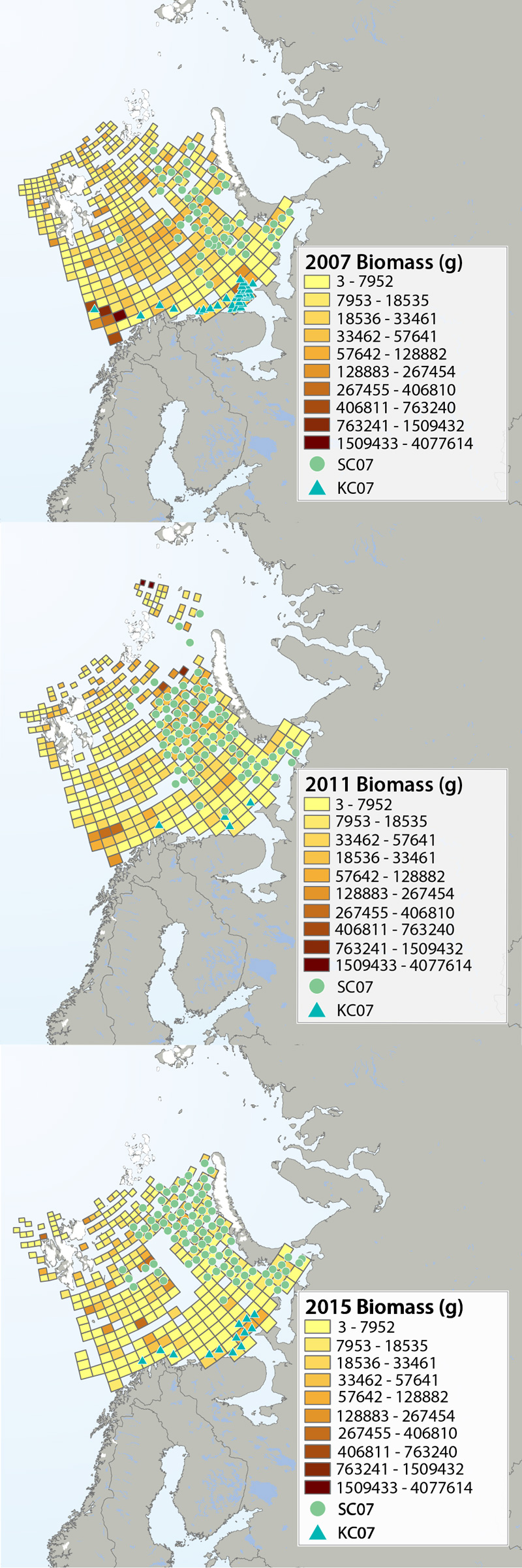
SAMBR - Biomass change over time
Megafauna distribution of biomass (g/15 min trawling) in the Barents Sea in 2007, 2011 and 2015. The green circles show the distribution of the snow crab as it spreads from east to west, and the blue triangles show the invasion of king crab along the coast of the southern Barents Sea. Data from Institute of Marine Research, Norway and the Polar Research Institute of Marine Fisheries and Oceanography, Murmansk, Russia.
STATE OF THE ARCTIC MARINE BIODIVERSITY REPORT - <a href=" https://arcticbiodiversity.is/findings/benthos" target="_blank">Chapter 3</a> - Page 95 - Figure 3.3.2
The annual joint Norwegian–Russian Ecosystem Survey provides from more than 400 stations and during extensive cruise tracks covering more or less the whole Barents Sea in August– September. The sampling is based on a regular grid spanning about 1.5 millionkm2 with fixed positions of stations which make it possible to measure changes in spatial distribution over time. The trawl is a Campelen 1800 bottom trawl rigged with rock-hopper groundgear and towed on double Warps. The mesh size is 80 mm (stretched) in the front and 16–22 mmin the cod end, allowing the capture and retention of smaller fish and the largest benthos from the seabed (benthic megafauna). The horizontal opening was 11.7 m, and the vertical opening 4–5 m (Teigsmark and Øynes, 1982). The trawl configuration and bottom contact was monitored remotely by SCANMAR trawl sensors. The standard distance between trawl stations was 35 nautical miles (65 km), except north and west of Svalbard where a stratified sampling was adapted to the steep continental shelve. The standard procedure was to tow 15 min after the trawl had made contact with the bottom, but the actual tow duration ranged between 5 min and 1 h and data were subsequently standardized to 15 min trawl time. Towing speed was 3 knots, equivalent to a towing distance of 0.75 nautical miles (1.4 km) during a 15 min tow. The trawl catches were recorded using the same procedures on the Russian and the Norwegian Research vessels to ensure comparability across Barents Sea regions. The benthic megafauna was separated from the fish and shrimp catch, washed, and sorted to lowest possible taxonomic level, in most cases to species, on-Board the vessel. Species identification was standardized between the researcher teams by annually exchanging the benthic expert’s among the vessels and taxon names were fixed each year according toWORMSwhen possible.This resulted in an Electronic identification manual and photo-compendium as a tool to standardize taxon identifications, in addition to various sources of identification literature. Difficult taxa were photographed and, in some cases, brought back as preserved voucher specimens for further identification. Wet-weight biomass was recorded with electronic scales in the ship laboratories for each taxon.The biomass determination included all fragments.
Simple
- Date (Publication)
- 2017-05
- Credit
-
Institute of Marine Research (IMR, Norway)
Polar Research Institute of Marine Fisheries and Oceanography (PINRO, Russia)
- Status
- Completed
- Point of contact
-
Organisation name Individual name Electronic mail address Role Institute of Marine Research (IMR, Norway)
Lis Lindal Jørgensen
Author Conservation of Arctic Flora and Fauna (CAFF)
Tom Barry
Point of contact
- Maintenance and update frequency
- Unknown
- Theme
-
-
CHAPTER3
-
Barents Sea
-
Marine
-
- Place
-
-
Benthos
-
- Access constraints
- Copyright
- Use constraints
- otherRestictions
- Spatial representation type
- Vector
- Language
- English
- Character set
- UTF8
- Topic category
-
- Oceans
- Begin date
- 2007-08-14
- End date
- 2013-08-14
))
- Supplemental Information
-
You can customize the template to suit your needs. You can add
and remove fields and fill out default information (e.g. contact details).
Fields you can not change in the default view may be accessible in the more
comprehensive (and more complex) advanced view. You can even use the XML editor
to create custom structures, but they have to be validated by the system, so
know what you do :-)
Digital transfer options
- OnLine resource
-
Protocol Linkage Name WWW:LINK-1.0-http--link
OGC:WMS-1.1.1-http-get-map
WWW:DOWNLOAD-1.0-http--download
https://geo.abds.is/geonetwork/srv/api/records/fdd43496-9874-45f6-897e-123dc6e61f4b/attachments/Fig332.zip Fig332.zip
- Hierarchy level
- Dataset
Conformance result
- Date (Publication)
Metadata
- File identifier
- fdd43496-9874-45f6-897e-123dc6e61f4b XML
- Metadata language
- English
- Character set
- UTF8
- Date stamp
- 2026-02-19T17:47:10.395594383Z
- Metadata standard name
-
ISO 19115:2003/19139
- Metadata standard version
-
1.0
- Metadata author
-
Organisation name Individual name Electronic mail address Role Conservation of Arctic Flora and Fauna (CAFF)
Hólmgrímur Helgason
Publisher
)))