 CAFF - Arctic Biodiversity Data Service (ABDS)
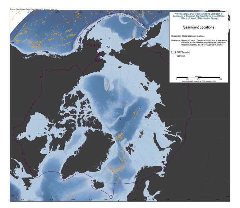
Seamounts
Seamounts and knolls are ‘undersea mountains’, the former rising more than 1000 m from the seafloor. These features provide important habitats for aquatic predators, demersal deep-sea fish and benthic invertebrates. However most seamounts have not been surveyed and their numbers and locations are not well known. Previous efforts to locate and quantify seamounts have used relatively coarse bathymetry grids. Here we use global bathymetric data at 30 arc-second resolution to identify seamounts and knolls. We identify 33,452 seamounts and 138,412 knolls, representing the largest global set of identified seamounts and knolls to date. We compare estimated seamount numbers, locations, and depths with validation sets of seamount data from New Zealand and Azores. This comparison indicates the method we apply finds 94% of seamounts, but may overestimate seamount numbers along ridges and in areas where faulting and seafloor spreading creates highly complex topography. The seamounts and knolls identified herein are significantly geographically biased towards areas surveyed with shipbased soundings. As only 6.5% of the ocean floor has been surveyed with soundings it is likely that new seamounts will be uncovered as surveying improves. Seamount habitats constitute approximately 4.7% of the ocean floor, whilst knolls cover 16.3%. Regional distribution of these features is examined, and we find a disproportionate number of productive knolls, with a summit depth of o1.5 km, located in the Southern Ocean. Less than 2% of seamounts are within marine protected areas and the majority of these are located within exclusive economic zones with few on the High Seas. The database of seamounts and knolls resulting from this study will be a useful resource for researchers and conservation planners.
Reference:
Yesson, C., et al., The global distribution of seamounts based on 30 arc seconds bathymetry data. Deep-Sea Research I (2011
Simple
- Date (Revision)
- 2016-02
- Status
- Completed
http://caff.is
- Hours of service
- 08:00 - 16:00 GMT
- Maintenance and update frequency
- As needed
- Theme
-
- abiotic
- marine
- seafloor
- Place
-
- protected areas
- Access constraints
- Copyright
- Use constraints
- otherRestictions
- Spatial representation type
- Vector
- Denominator
- 50000
- Metadata language
- English
- Character set
- UTF8
))
- Supplemental Information
-
You can customize the template to suit your needs. You can add
and remove fields and fill out default information (e.g. contact details).
Fields you can not change in the default view may be accessible in the more
comprehensive (and more complex) advanced view. You can even use the XML editor
to create custom structures, but they have to be validated by the system, so
know what you do :-)
- Protocol
- WWW:LINK-1.0-http--link
- Protocol
- OGC:WMS-1.3.0-http-get-map
- Name
- seamounts_yesson
- Description
- WMS Service
- OnLine resource
-
Figure 1.17-1 Seamount Locations.jpg
(
WWW:DOWNLOAD-1.0-http--download
)
Image
- OnLine resource
-
Seamounts_yesson.zip
(
WWW:DOWNLOAD-1.0-http--download
)
Shape file
- OnLine resource
-
seamounts_yesson
(
OGC:WMS-1.3.0-http-get-map
)
seamounts_yesson
- Hierarchy level
- Dataset
Conformance result
- Date (Publication)
- File identifier
- 5ab2a3b0-6af9-4946-b491-c3c42da3a190 XML
- Metadata language
- English
- Character set
- UTF8
- Date stamp
- 2023-02-13T14:00:05
- Metadata standard name
- ISO 19115:2003/19139
- Metadata standard version
- 1.0
http://caff.is
- Hours of service
- 08:00 - 16:00 GMT
Overviews
Spatial extent
Provided by