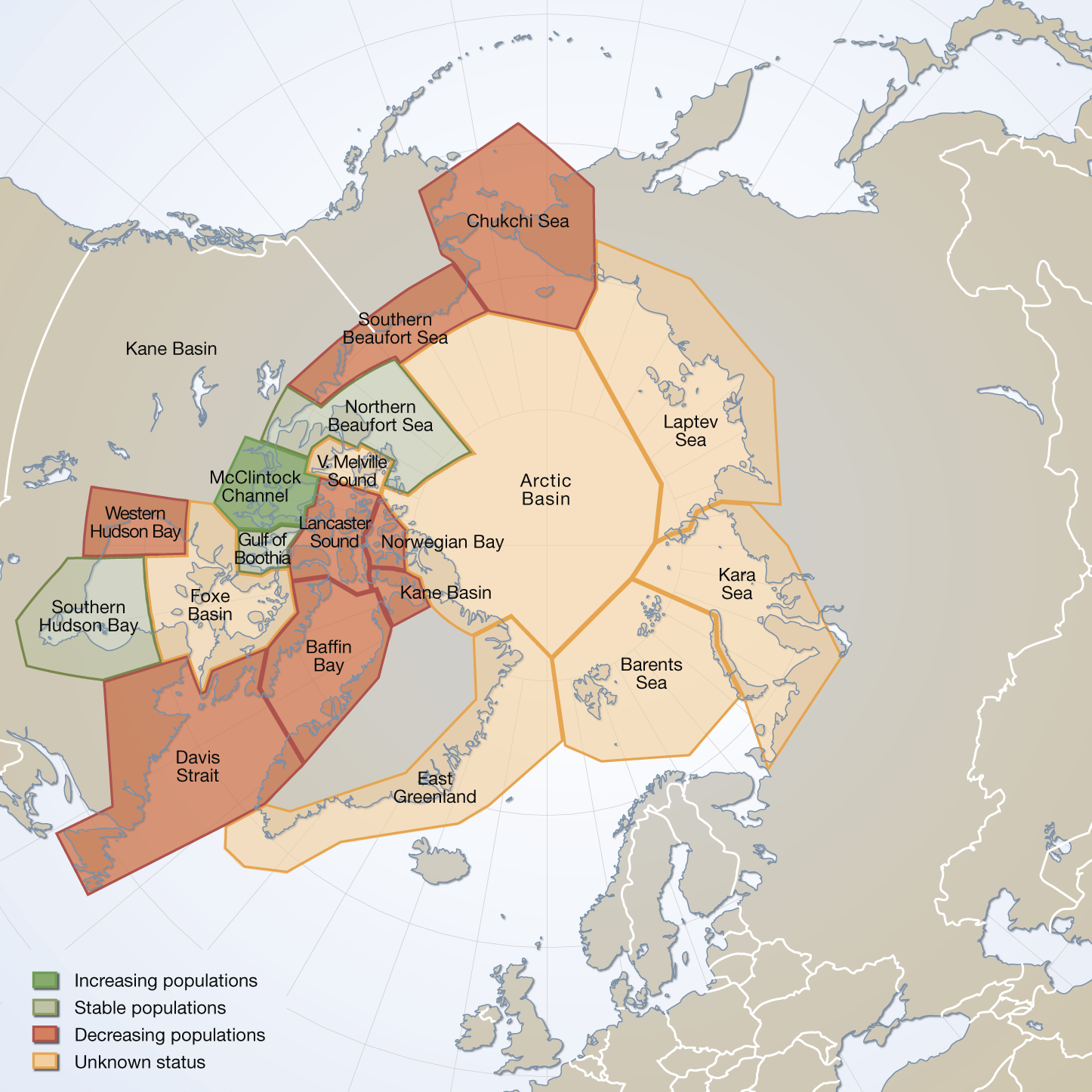
Circumpolar map of all polar bear subpopulation
Circumpolar map of all polar bear subpopulation as recognized by the IUCN/Polar Bear Specialist Group in 2009 (PBSG 2010a). Total area covered = 24 mill. km(2).
Vongraven, D and Peacock, E. Development of a pan-Arctic monitoring plan for polar bears:background paper.
Published in the Arctic Biodiversity trends 2010, Indicator #01 - released in May 2010
Updated in feb.2025 with spatial data from 2022
Simple
- Alternate title
- caff
- Date (Publication)
- 2015-02-03
- Date (Revision)
- Date (Creation)
- Credit
- Conservation of Arctic Flora and Fauna (CAFF www.caff.is) working group of the Arctic Council
- Maintenance and update frequency
- Unknown
- Keywords
-
- polar bear
- distribution
- boundary
- populations
- Keywords
-
- populations
- subpopulation
- Ursus maritimus
- Metadata language
- English
))
- Reference system identifier
- EPSG / 3408
- OnLine resource
-
pbrs_2022_4326
(
OGC:WMS
)
WMS Service
- OnLine resource
-
polarbear.png
(
WWW:DOWNLOAD-1.0-http--download
)
Image
- OnLine resource
-
Arctic Biodiversity trends 2010 - #01 Polar Bears
(
WWW:LINK-1.0-http--link
)
Arctic Biodiversity trends 2010 - #01 Polar Bears
- OnLine resource
-
Download Mammals chapter - Arctic Biodiversity Assessment: Status and trends in Arctic biodiversity
(
WWW:LINK-1.0-http--link
)
Download Mammals chapter - Arctic Biodiversity Assessment: Status and trends in Arctic biodiversity
- OnLine resource
-
Polar_Bear_subpopulation.jpg
(
WWW:DOWNLOAD-1.0-http--download
)
ABA - Table 3.5
- OnLine resource
-
Spatial data from 2022
(
FILE:GEO
)
Shape file (shp)
- Hierarchy level
- Dataset
Conformance result
- Date (Publication)
- Pass
- File identifier
- 1f4afeae-8a06-4ac3-a01e-971b139a0f93 XML
- Metadata language
- English
- Character set
- UTF16
- Hierarchy level
- Dataset
- Date stamp
- 2025-02-17T14:09:45
- Metadata standard version
- 1.2
Overviews

Spatial extent
))
Provided by

 CAFF - Arctic Biodiversity Data Service (ABDS)