 CAFF - Arctic Biodiversity Data Service (ABDS)
Canada
Type of resources
Available actions
Topics
Keywords
Contact for the resource
Provided by
Years
Representation types
Update frequencies
status
Scale
-
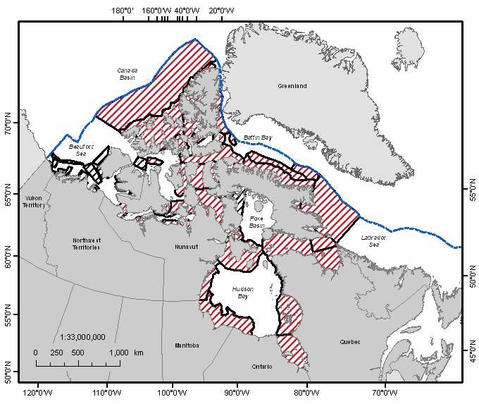
A national Canadian Science Advisory Secretariat (CSAS) science advisory process was held in Winnipeg, Manitoba from June 14-17, 2011 to provide science advice on the identification of Ecologically and Biologically Significant Areas (EBSAs) in the Canadian Arctic based on guidance developed by Fisheries and Oceans Canada. This science advisory process focused on the identification of EBSAs within the following marine biogeographic units: the Hudson Bay Complex, the Arctic Basin, the Western Arctic, the Canadian Arctic Archipelago and the Eastern Arctic. Source: <a href="http://www.dfo-mpo.gc.ca/Library/344747.pdf" target="_blank">Fisheries and Oceans Canada</a> Reference: DFO. 2011. Identification of Ecologically and Biologically Significant Areas (EBSA) in the Canadian Arctic. DFO Can. Sci. Advis. Sec. Sci. Advis. Rep. 2011/055. DFO. 2011. Identification of Ecologically and Biologically Significant Areas (EBSAs) in the Canadian Arctic; June 14-17, 2011. DFO Can. Sci. Advis. Sec. Proceed. Ser. 2011/047.
-
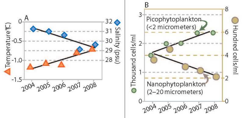
Trends in water temperature and salinity (A) and density of phytoplankton of two size ranges (B), Canada Basin, 2004 to 2008. Stratification of the water column increased throughout the Canada Basin over a recent five-year period, accompanied by a change in phytoplankton communities. The upper ocean layer showed trends of increased temperature and decreased salinity (Figure 18A), which combine to make this layer progressively less dense. The layer of water below this did not change in density over this period (not shown). The larger size class of phytoplankton (which would include diatoms) decreased in abundance, while the smaller types of plankton increased (Figure 18B). In addition to the trends shown, nutrient content in the upper ocean water layer decreased. Abundance of microbes (bacteria and similar organisms) that subsist on organic matter increased. Total phytoplankton biomass, however, remained unchanged. If this trend towards smaller species of phytoplankton and microbes is sustained, it may lead to reduced production of zooplankton, an impact that would be transmitted through the food web to birds, fish and mammals. Published in the Life Linked to Ice released in 2013, page 30. Life Linked to Ice: A guide to sea-ice-associated biodiversity in this time of rapid change. CAFF Assessment Series No. 10. Conservation of Arctic Flora and Fauna, Iceland. ISBN: 978-9935-431-25-7.
-
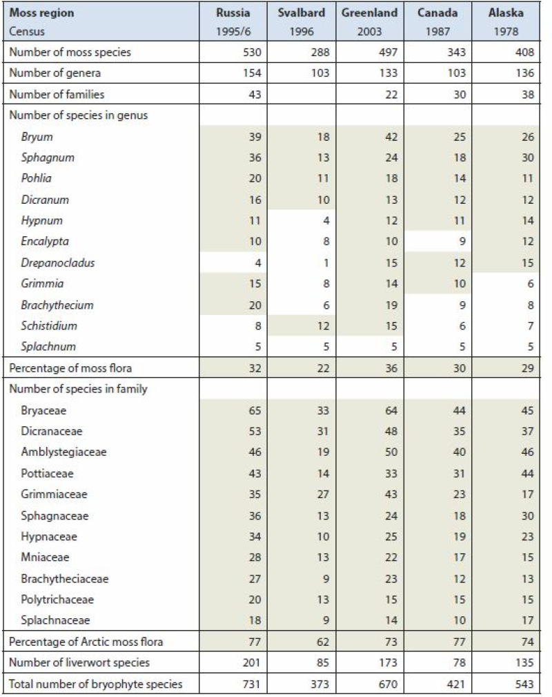
Arctic Biodiversity Assessment (ABA) 2013. Table 9.5. Species numbers of species-rich moss genera and families. Numbers highlighted in grey fields are used in calculating the percentage of the total moss flora. Listed are Splachnum, genera with at least 10 species and families with at least nine species. Conservation of Arctic Flora and Fauna, CAFF 2013 - Akureyri . Arctic Biodiversity Assessment. Status and Trends in Arctic biodiversity. - Plants(Chapter 9) page 333
-
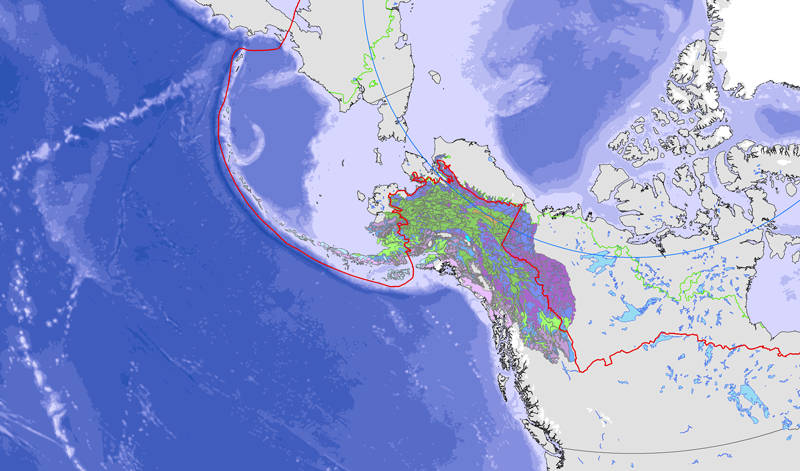
<a href="http://caff.is/strategies-series/359-the-alaska-yukon-region-of-the-circumboreal-vegetation-map-cbvm" target="_blank"> <img width="150px" height="150px" alt="logo" align="left" hspace="10px" src="http://geo.abds.is/geonetwork/images/flora_logo.png"> </a>A map of boreal vegetation for the Alaska-Yukon region was developed to contribute to the circumboreal vegetation mapping (CBVM) project. The effort included developing a map of bioclimates with 12 bioclimate zones, a map of biogeographic provinces with Alaska-Yukon and Aleutian provinces, and a map of geographic sectors with six sectors that provided the basis for classification of boreal vegetation. Vegetation mapping was done at 1:7.5 million scale using the mapping protocols of the CBVM team. Mapping used MODIS imagery as the basis for manual image interpretation and an integrated-terrain-unit approach, which included classifications for bioclimate, physiography, generalized geology, permafrost, disturbance, growth from, geographic sector, and vegetation. Vegetation was mapped at two hierarchical levels: (1) formation group differentiating zonal and azonal systems; and (2) geographic sectors based on bioclimatic zonation and dominant species that characterize broad longitudinal regions or biogeographic provinces. Each of the 19 map units was described by identifying the dominant and characteristic species and its climatic and landscape characteristics, as well as references that relate to the unit.