 CAFF - Arctic Biodiversity Data Service (ABDS)
monitoring
Type of resources
Available actions
Topics
Keywords
Contact for the resource
Provided by
Years
Formats
Representation types
Update frequencies
status
-
Long-term monitoring programs on benthic fauna are missing for large areas of the Arctic. In areas where repeated monitoring has occurred, it is difficult to compare data due to different sampling approaches and different targets of monitoring efforts. There is a need for an international standardization of long- term benthic monitoring. The CBMP Benthos Expert Network has identified potential ways to improve benthic monitoring coverage, and has come up with a map showing a Pan Arctic station map.
-
<img width="80px" height="67px" alt="logo" align="left" hspace="10px" src="http://geo.abds.is/geonetwork/srv/eng//resources.get?uuid=7d8986b1-fbd1-4e1a-a7c8-a4cef13e8eca&fname=cbird.png">The Circumpolar Seabird Monitoring Plan is designed to 1) monitor populations of selected Arctic seabird species, in one or more Arctic countries; 2) monitor, as appropriate, survival, diets, breeding phenology, and productivity of seabirds in a manner that allows changes to be detected; 3) provide circumpolar information on the status of seabirds to the management agencies of Arctic countries, in order to broaden their knowledge beyond the boundaries of their country thereby allowing management decisions to be made based on the best available information; 4) inform the public through outreach mechanisms as appropriate; 5) provide information on changes in the marine ecosystem by using seabirds as indicators; and 6) quickly identify areas or issue in the Arctic ecosystem such as declining biodiversity or environmental pressures to target further research and plan management and conservation measures. - <a href="http://caff.is" target="_blank"> Circumpolar Seabird Monitoring plan </a>
-
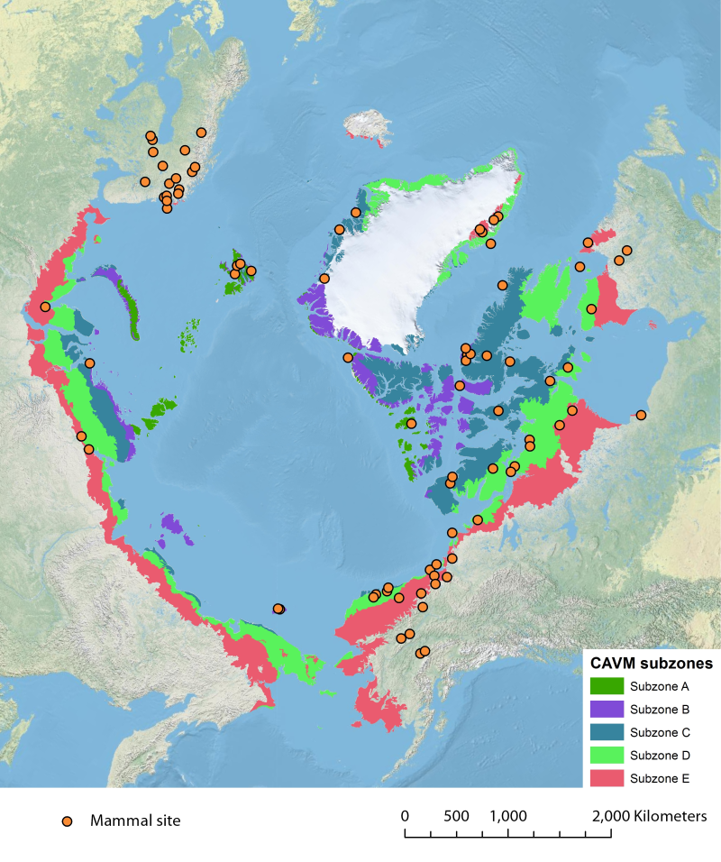
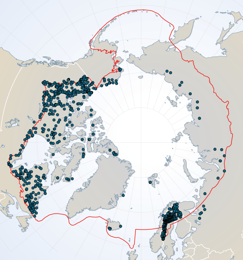
Location of long-term mammal monitoring sites and programs. Comes from the Arctic Terrestrial Biodiversity Monitoring Plan is developed to improve the collective ability of Arctic traditional knowledge holders, northern communities and scientists to detect, understand and report on long-term change in Arctic terrestrial ecosystems and biodiversity..
-
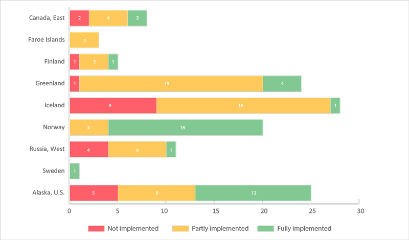
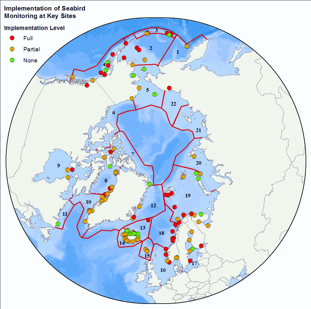
The number of key sites (monitored colonies) for seabirds (in 22 CSMP ecoregions) by country (a total of 125 sites). Sites are categorized as having fully, partially, or not met the CSMP criteria for parameters monitored (see 2.6.2). Data were from Appendix 3 of the CSMP (Irons et al. 2015); the degree of implementation may have changed at some sites since this summary was compiled. STATE OF THE ARCTIC MARINE BIODIVERSITY REPORT - <a href="https://arcticbiodiversity.is/findings/seabirds" target="_blank">Chapter 3</a> - Page 134 - Figure 3.5.2
-
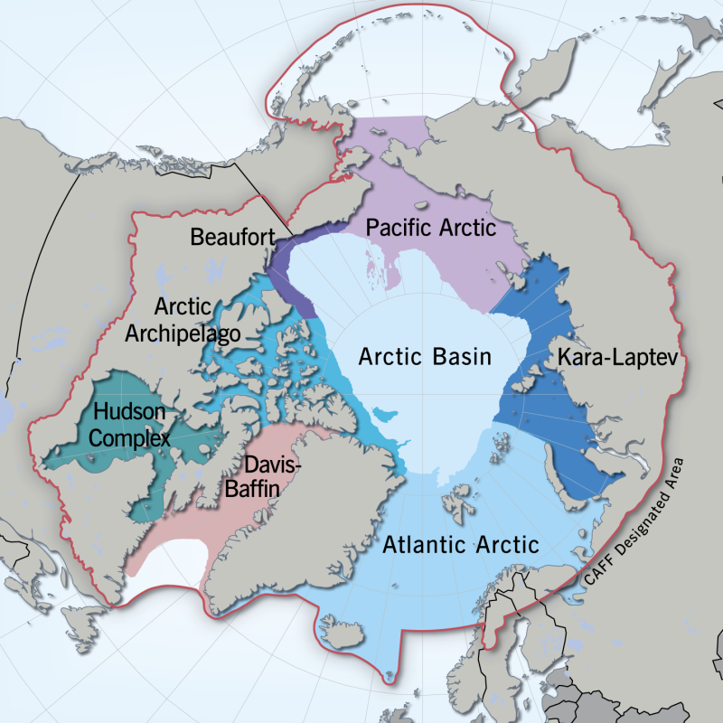
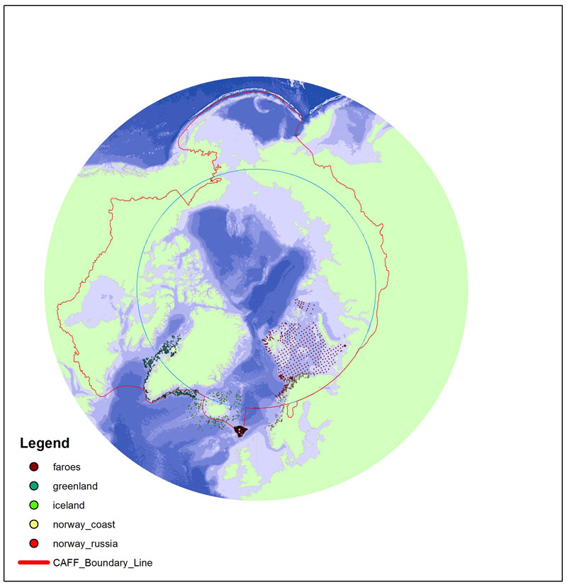
Regional divisions of the marine Arctic, as determined by the Marine Expert Monitoring Group of the Circumpolar Biodiversity Monitoring Programme (CBMP). The Circumpolar Marine Biodiversity Monitoring plan identifies eight Arctic Marine Areas where a suite of common parameters, sampling approaches and indicators will be used. Regionally specific parameters may also be applied. Exact boundaries may change over time to reflect changing bio-physical conditions. <a href="http://caff.is/marine/marine-monitoring-publications/3-arctic-marine-biodiversity-monitoring-plan" target="_blank"> Published in the Arctic Marine Biodiversity Monitoring Plan, Chapter 2, page20 - released in 2011 </a>
-
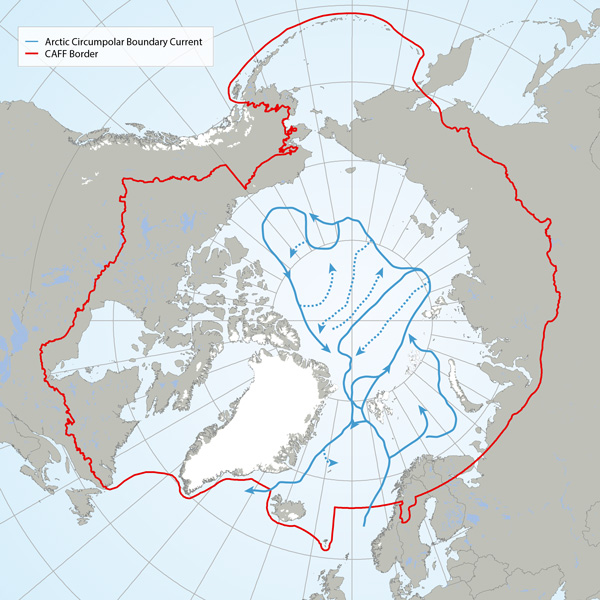
The Arctic Basin where suggested future long-term monitoring of trawl-megafauna should capture possible changes along the flow of the Arctic Circumpolar Boundary Current (Figure A, blue line) and the Arctic deep-water exchange (Figure b, green line). Adapted from Bluhm et al. (2015). STATE OF THE ARCTIC MARINE BIODIVERSITY REPORT - <a href="https://arcticbiodiversity.is/findings/benthos" target="_blank">Chapter 3</a> - Page 88 - Figure 3.3.1
-
The baseline survey and ongoing monitoring required to adequately describe Arctic arthropod biodiversity and to identify trends is largely lacking. Although some existing publications reporting long-term and extensive sampling exist, they are limited in species level information, taxonomic coverage and/or geographic location/extent (Figure 3-19) STATE OF THE ARCTIC TERRESTRIAL BIODIVERSITY REPORT - Chapter 3 - Page 44 - Figure 3.19
-
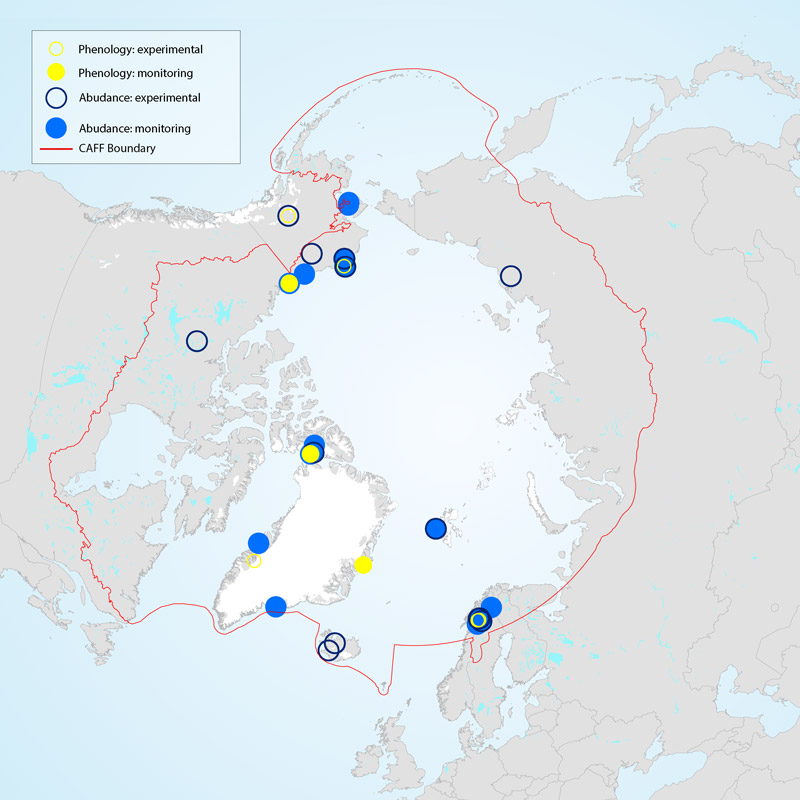
Vegetation monitoring occurs across the Arctic, but the duration of monitoring efforts is variable and is dependent upon both study design and access to resources. Although many field studies on vegetation have been conducted in the Arctic (Figure 3-5), not all can be considered monitoring since some recorded only select measurements over limited time frames. Studies reporting on abundance and composition of vegetation reflect a larger and more widespread geographical coverage than the typically more site-limited and time-consuming phenology studies (Figure 3-5). Geographical gaps in coverage of Siberia and large parts of the Canadian Arctic are evident. STATE OF THE ARCTIC TERRESTRIAL BIODIVERSITY REPORT - Chapter 3 - Page 34 - Figure 3.5
-
River dataset showing location of study sites in rivers for the Arctic Freshwater Biodiversity Monitoring Plan. Published in the Arctic Freshwater Monitoring Plan Brochure released in 2013 http://www.caff.is/monitoring-series/view_document/277-arctic-freshwater-biodiversity-monitoring-plan-brochure
-
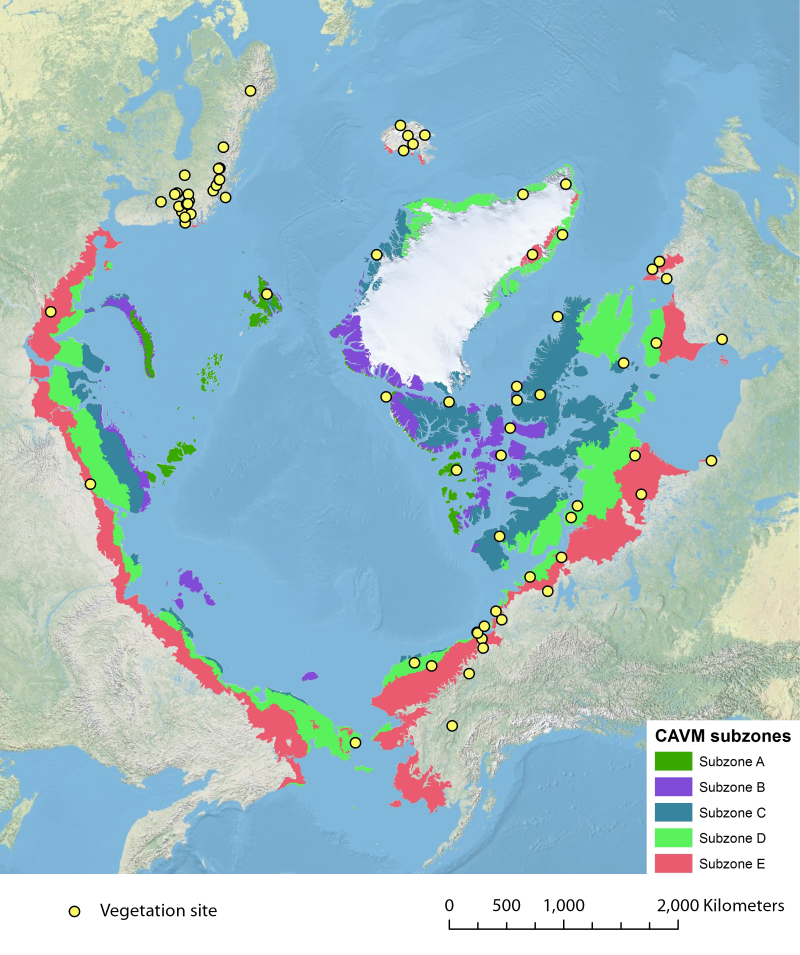
Location of long-term vegetation (including fungi, non-vascular and vascular plants) monitoring sites and programs. Comes from the Arctic Terrestrial Biodiversity Monitoring Plan is developed to improve the collective ability of Arctic traditional knowledge holders, northern communities and scientists to detect, understand and report on long-term change in Arctic terrestrial ecosystems and biodiversity. The report can be seen here http://www.caff.is/publications/view_document/256-arctic-terrestrial-biodiversity-monitoring-plan The monitoring locations are place over the Circumpolar Arctic bioclimate subzones (CAVM Team 2003) http://www.caff.is/flora-cfg/circumpolar-arctic-vegetation-map