 CAFF - Arctic Biodiversity Data Service (ABDS)
terrestrial
Type of resources
Available actions
Topics
Keywords
Contact for the resource
Provided by
Years
Formats
Representation types
Update frequencies
status
Scale
-
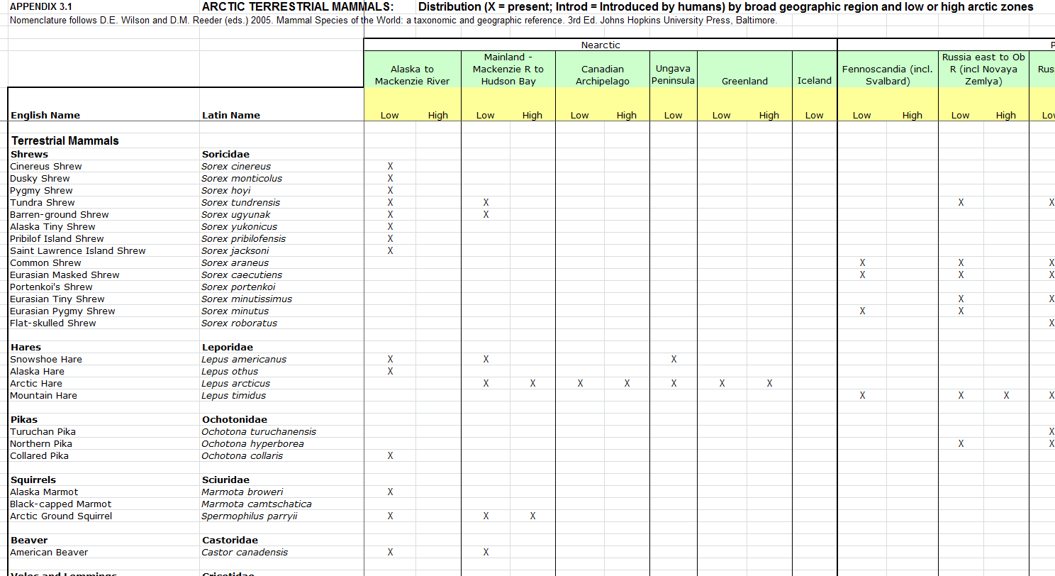
Distribution by broad geographic region and low or high arctic zones.
-
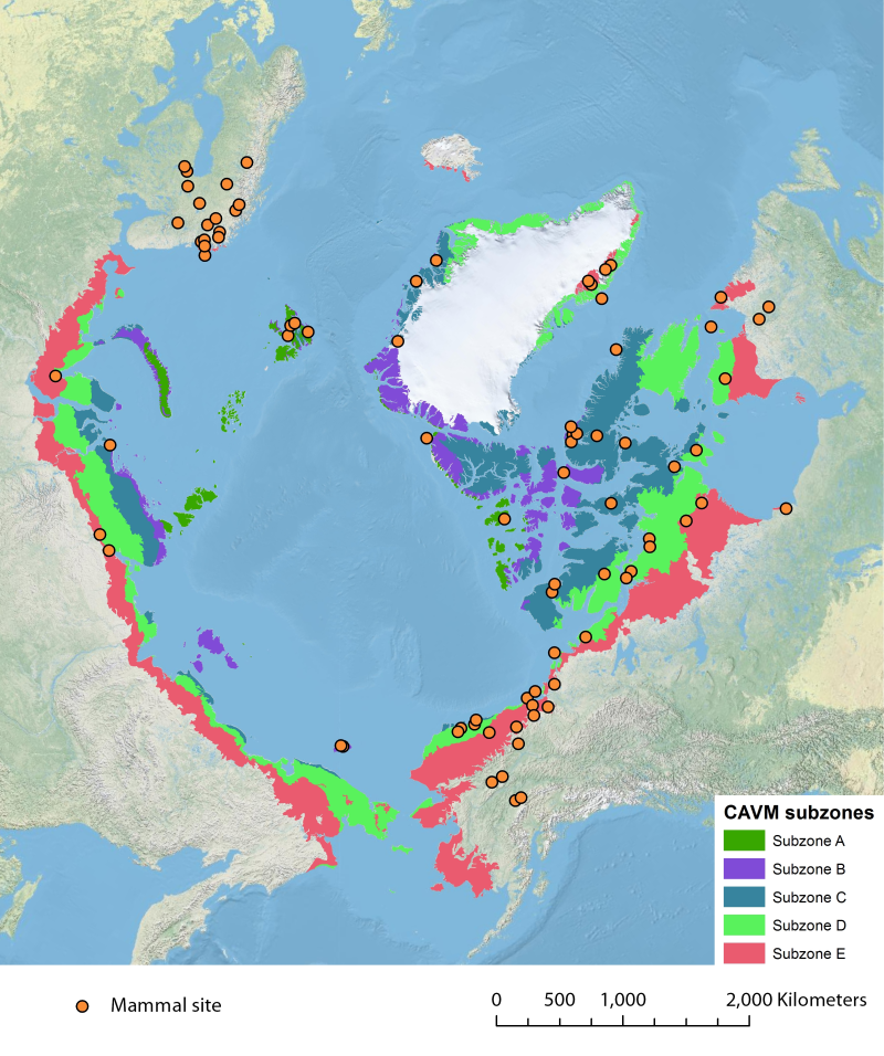
Location of long-term mammal monitoring sites and programs. Comes from the Arctic Terrestrial Biodiversity Monitoring Plan is developed to improve the collective ability of Arctic traditional knowledge holders, northern communities and scientists to detect, understand and report on long-term change in Arctic terrestrial ecosystems and biodiversity..
-
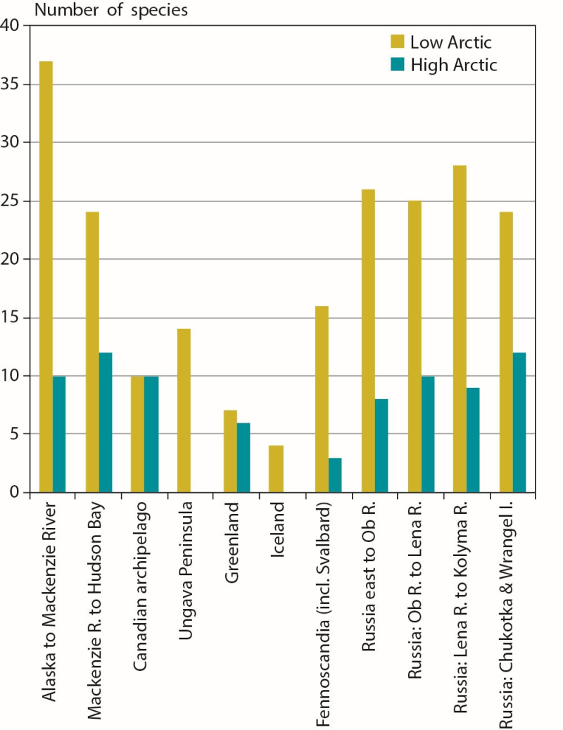
Number of terrestrial mammal species occupying low and high Arctic zones in each of the circumpolar Arctic regions. Conservation of Arctic Flora and Fauna, CAFF 2013 - Akureyri . Arctic Biodiversity Assessment. Status and Trends in Arctic biodiversity. - Mammals(Chapter 3) page 83
-
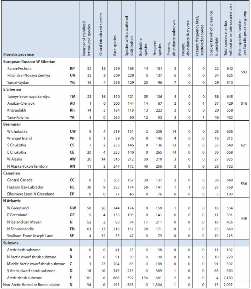
Summary of Arctic vascular plant species and distribution by Arctic flora province and subzone based on Elven (2007). Arctic floristic provinces, subzones (A-E), neighbouring boreal or boreal-alpine zone (N) and distribution derived from Elven (2007). Arctic Biodiversity Assessment - Table 9.1 Conservation of Arctic Flora and Fauna, CAFF 2013 - Akureyri . Arctic Biodiversity Assessment. Status and Trends in Arctic biodiversity. - Plants(Chapter 9) page 321
-
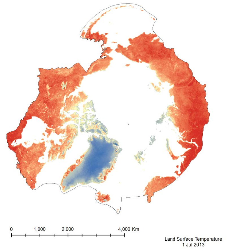
The MODIS Land Surface Temperature (LST) product provided is a monthlycomposite configured on a 0.05° Climate Model Grid (CMG). It includes both daytime andnighttime surface temperatures, taken at 11 um and 4 um (night). This product has beenscaled. To convert the raster values to a Kelvin temperature scale, multiply by a factor of 0.02.
-
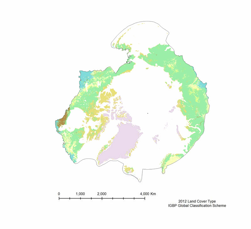
The MODIS Land Cover Type product is created yearly using three landclassification schemes; the International Geosphere Biosphere Programme (IGBP)classification scheme, the Univertiy of Maryland (UMD) classification scheme, and aMODIS-derived Leaf Area Index /Fraction of Photosynthetically Active Radiation(LAI/fPAR) classification scheme (Table 3). The International Geosphere Biosphere Programme (IGBP) identifies seventeenland cover classes, including eleven natural vegetation classes, three non-vegetated landclasses, and three developed land classes. The product provided is derived using the samealgorithm as the 500 m Land Cover Type (MOD12Q1), but is on a 0.05° Climate Model Grid(CMG), that has been clipped to the pan-Arctic extent. The UMD classification scheme issimilar to the IGBP classification scheme, but it excludes the Permanent wetlands,Cropland/Natural vegetation mosaic, and the Snow and ice classes. The LAI/fPARclassification scheme is the smallest of the three, and focuses on forest structure; it only haseleven classes. All three land cover classification schemes are provided, but the IGBPclassification scheme is the most amenable to the Pan-Arctic region.
-
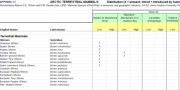
Appendix 3.1 Arctic Terrestrial mammals: Distribution (X = present; Introd = Introduced by humans) by broad geographic region and low or high arctic zones Nomenclature follows D.E. Wilson and D.M. Reeder (eds.) 2005. Mammal Species of the World: a taxonomic and geographic reference. 3rd Ed. Johns Hopkins University Press, Baltimore.
-
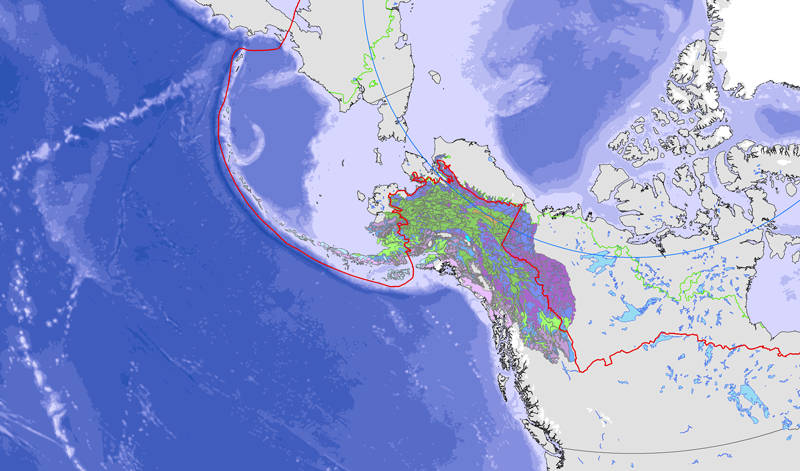
<a href="http://caff.is/strategies-series/359-the-alaska-yukon-region-of-the-circumboreal-vegetation-map-cbvm" target="_blank"> <img width="150px" height="150px" alt="logo" align="left" hspace="10px" src="http://geo.abds.is/geonetwork/images/flora_logo.png"> </a>A map of boreal vegetation for the Alaska-Yukon region was developed to contribute to the circumboreal vegetation mapping (CBVM) project. The effort included developing a map of bioclimates with 12 bioclimate zones, a map of biogeographic provinces with Alaska-Yukon and Aleutian provinces, and a map of geographic sectors with six sectors that provided the basis for classification of boreal vegetation. Vegetation mapping was done at 1:7.5 million scale using the mapping protocols of the CBVM team. Mapping used MODIS imagery as the basis for manual image interpretation and an integrated-terrain-unit approach, which included classifications for bioclimate, physiography, generalized geology, permafrost, disturbance, growth from, geographic sector, and vegetation. Vegetation was mapped at two hierarchical levels: (1) formation group differentiating zonal and azonal systems; and (2) geographic sectors based on bioclimatic zonation and dominant species that characterize broad longitudinal regions or biogeographic provinces. Each of the 19 map units was described by identifying the dominant and characteristic species and its climatic and landscape characteristics, as well as references that relate to the unit.
-
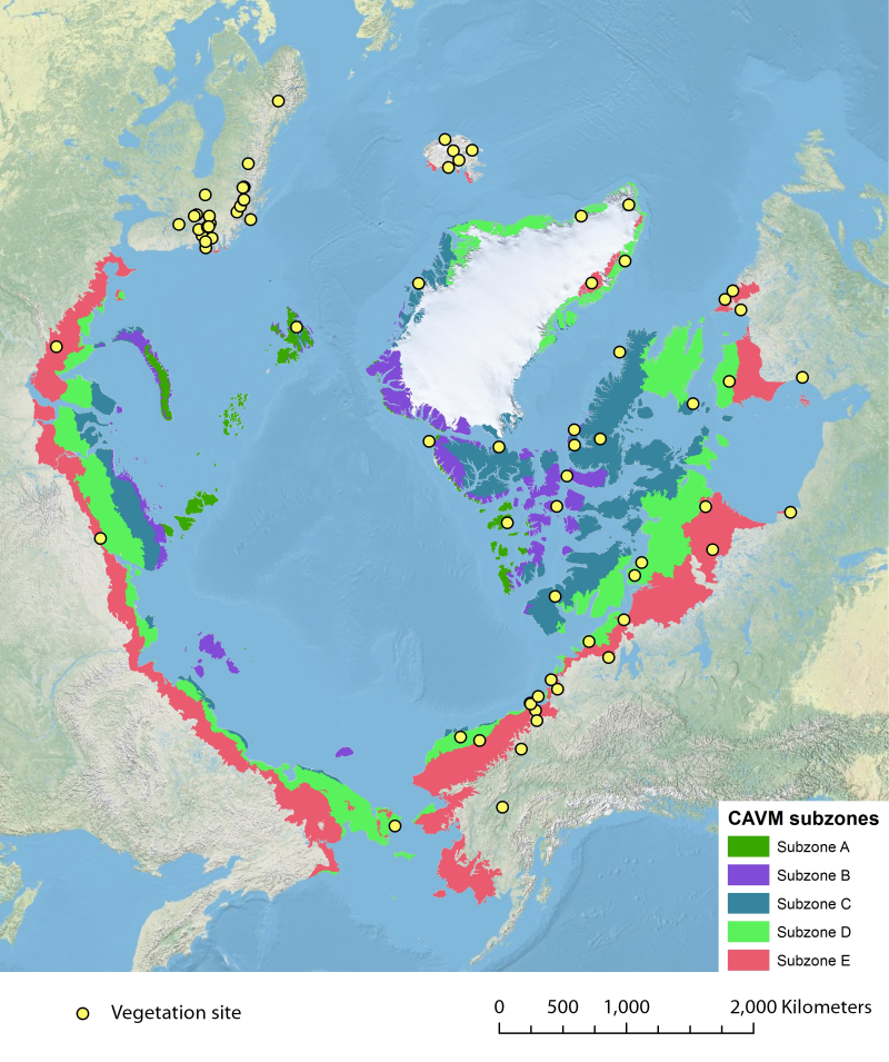
Location of long-term vegetation (including fungi, non-vascular and vascular plants) monitoring sites and programs. Comes from the Arctic Terrestrial Biodiversity Monitoring Plan is developed to improve the collective ability of Arctic traditional knowledge holders, northern communities and scientists to detect, understand and report on long-term change in Arctic terrestrial ecosystems and biodiversity. The report can be seen here http://www.caff.is/publications/view_document/256-arctic-terrestrial-biodiversity-monitoring-plan The monitoring locations are place over the Circumpolar Arctic bioclimate subzones (CAVM Team 2003) http://www.caff.is/flora-cfg/circumpolar-arctic-vegetation-map
-
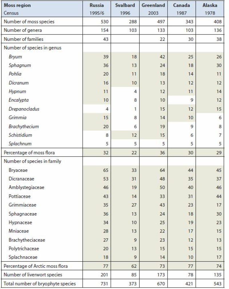
Arctic Biodiversity Assessment (ABA) 2013. Table 9.5. Species numbers of species-rich moss genera and families. Numbers highlighted in grey fields are used in calculating the percentage of the total moss flora. Listed are Splachnum, genera with at least 10 species and families with at least nine species. Conservation of Arctic Flora and Fauna, CAFF 2013 - Akureyri . Arctic Biodiversity Assessment. Status and Trends in Arctic biodiversity. - Plants(Chapter 9) page 333